
Mynd:Topographic map of Åland.svg

Size of this PNG preview of this SVG file: 681 × 516 pixels. Aðrar upploysnir: 317 × 240 pixels | 634 × 480 pixels | 1.014 × 768 pixels | 1.280 × 970 pixels | 2.560 × 1.940 pixels.
Upprunafíla (SVG fíle, nominelt 681 × 516 pixel, fíle stødd: 172 KB)
Samandráttur
This W3C-unspecified vector image was created with Inkscape .
| Frágreiðing |
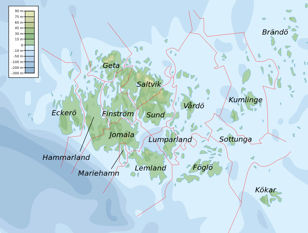
English: Topographic map of the Åland Islands.
Français : Carte topographique des îles d'Åland.
Suomi: Ahvenanmaan topografinen kartta.
Approximate limits:
|
| Dagur | |
| Kelda |
Self-made in Inkscape. Boundaries and municipality borders based on Image:Alandmunicipalities.png. Topography based on public domain GLOBE data from NOAA (http://www.ngdc.noaa.gov/mgg/topo/gltiles.html). Bathymetry adapted after a small slice from T. Seifert, F. Tauber, B. Kayser: 2001: "A high resolution spherical grid topography of the Baltic Sea – 2nd edition", Baltic Sea Science Congress, Stockholm 25-29. November 2001, Poster #147, www.io-warnemuende.de/iowtopo. Colors and overall look based on maps by User:Bamse. |
| Høvundur | Mysid |
| Other versions | Derivative works of this file: Aland EU.svg |

|
This SVG file contains embedded text that can be translated into your language, using any capable SVG editor, text editor or the SVG Translate tool. For more information see: About translating SVG files. |
Lisensur
I, the copyright holder of this work, hereby publish it under the following licenses:

|
Loyvi verður givi at avrita, bera út og/ella broyta hetta skjal undir treytunum hjá GNU Free Documentation License, versión 1.2 ella einhvør seinni versjón ið er útgivin av Free Software Foundation; uttan nakað óbroytiligt brot, uttan forsíðutekst og uttan baksíðutekst. Eitt avrit av loyvinum er tikið við í brotinum ið nevnist GNU Free Documentation License. |
This file is licensed under the Creative Commons Attribution-Share Alike 4.0 International, 3.0 Unported, 2.5 Generic, 2.0 Generic and 1.0 Generic license.
- Tú ert vælkomin til:
- at deila – at avrita, breiða út og senda verkið
- at remiksa – at tillaga ella broyta verkið
- Undir hesum treytum:
- ognan – Tú mást ognarskrivað verkið á ein slíkan hátt sum er útgreinaður av høvundanum ella lisenseigaranum (men ikki á nakran hátt ið kundi bent á at hesin hevur góðkent teg ella tína nýtslu av verkinum).
- deil undir somu treytum – Um tú broytir, evnar til ella byggir víðari á hetta verk, so kanst tú bert útgeva verkið undir somu ella líkandi lisensi sum hesin.
Tú kanst velja tann lisens ið tú ynskir.
Søgan hjá fíluni
Trýst á dato/tíð fyri at síggja fíluna, sum hon sá út tá.
| Dagur/Tíð | Lítil mynd | Dimensjónir | Brúkari | Viðmerking | |
|---|---|---|---|---|---|
| streymur | 12. feb 2008 kl. 11:06 | | 681 × 516 (172 KB) | Mysid | border wouldn't work |
| 12. feb 2008 kl. 11:05 |  | 681 × 516 (172 KB) | Mysid | {{inkscape}} {{Information |Description={{en|Topographic map of the Åland Islands.}} {{fi|Ahvenanmaan topografinen kartta.}} |Source=Self-made in Inkscape.<br/>Boundaries and municipality borders based on [[:Imag |
Myndarslóðir
Hesar síður slóða til hesa mynd:
Alheims fílunýtsla
Aðrar wkiir brúka hesa fílu:
- Nýtsla á ar.wikipedia.org
- Nýtsla á az.wiktionary.org
- Nýtsla á ba.wikipedia.org
- Nýtsla á be.wikipedia.org
- Nýtsla á bs.wikipedia.org
- Nýtsla á de.wikipedia.org
- Nýtsla á en.wikipedia.org
- Nýtsla á et.wikipedia.org
- Nýtsla á fi.wikipedia.org
- Nýtsla á fr.wikipedia.org
- Nýtsla á fy.wikipedia.org
- Nýtsla á gd.wikipedia.org
- Nýtsla á he.wikipedia.org
- Nýtsla á is.wikipedia.org
- Nýtsla á kk.wikipedia.org
- Nýtsla á ky.wikipedia.org
- Nýtsla á lb.wikipedia.org
- Nýtsla á mi.wikipedia.org
- Nýtsla á no.wikipedia.org
- Nýtsla á os.wikipedia.org
- Nýtsla á rue.wikipedia.org
- Nýtsla á ru.wikipedia.org
- Nýtsla á simple.wiktionary.org
- Nýtsla á sv.wikipedia.org
- Nýtsla á uk.wikipedia.org
- Nýtsla á zh.wikipedia.org