
Mynd:Yangtze River Map.png
Ongin hægri upploysn varð funnin.
Yangtze_River_Map.png (576 × 355 pixel, stødd fílu: 123 KB, MIME-slag: image/png)
Samandráttur
| Frágreiðing |
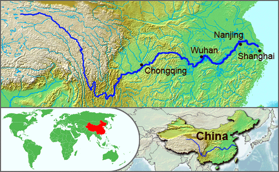
English: The underlying topographic maps used in this image come from the Demis Web Map Server, and are in the public domain. The world locator map is derived from :Image:BlankMap-World.png. I added the feature layers myself. —Papayoung ☯ 20:57, 1 October 2005 (UTC) |
| Dagur | 1 oktober 2005 (original upload date) |
| Kelda | Transferred from en.wikipedia to Commons by Common Good using CommonsHelper. |
| Høvundur | The original uploader was Papayoung at enskt Wikipedia. |
| Other versions |
|
.JPG)
Lisensur
| Henda fíla er gjørd atkomulig undir Creative Commons Navngev-Deil á sama hátt 3.0 Unported loyvinum. Subject to disclaimers. | ||
| ||
| This licensing tag was added to this file as part of the GFDL licensing update. |

|
Loyvi verður givi at avrita, bera út og/ella broyta hetta skjal undir treytunum hjá GNU Free Documentation License, versión 1.2 ella einhvør seinni versjón ið er útgivin av Free Software Foundation; uttan nakað óbroytiligt brot, uttan forsíðutekst og uttan baksíðutekst. Eitt avrit av loyvinum er tikið við í brotinum ið nevnist GNU Free Documentation License. Subject to disclaimers. |
Original upload log
The original description page was here. All following user names refer to en.wikipedia.
- 2005-10-01 20:51 Papayoung 576×355× (125604 bytes) The underlying topographic maps used in this image come from the [http://www2.demis.nl/mapserver/mapper.asp Demis Web Map Server], and are in the public domain. The world locator map is derived from [[Commons:Image:BlankMap-World.png|BlankMap-World.png]].
- 2005-09-25 22:57 Papayoung 936×363× (221574 bytes) The underlying topographic maps used in this image come from the [http://www2.demis.nl/mapserver/mapper.asp Demis Web Map Server], and are in the public domain. I added the feature layers myself. —~~~~
Søgan hjá fíluni
Trýst á dato/tíð fyri at síggja fíluna, sum hon sá út tá.
| Dagur/Tíð | Lítil mynd | Dimensjónir | Brúkari | Viðmerking | |
|---|---|---|---|---|---|
| streymur | 7. mai 2009 kl. 20:30 | | 576 × 355 (123 KB) | File Upload Bot (Magnus Manske) | {{BotMoveToCommons|en.wikipedia|year={{subst:CURRENTYEAR}}|month={{subst:CURRENTMONTHNAME}}|day={{subst:CURRENTDAY}}}} {{Information |Description={{en|The underlying topographic maps used in this image come from the [http://www2.demis.nl/mapserver/mapper |
Myndarslóðir
Hesar síður slóða til hesa mynd:
Alheims fílunýtsla
Aðrar wkiir brúka hesa fílu:
- Nýtsla á af.wikipedia.org
- Nýtsla á als.wikipedia.org
- Nýtsla á am.wikipedia.org
- Nýtsla á ary.wikipedia.org
- Nýtsla á ast.wikipedia.org
- Nýtsla á as.wikipedia.org
- Nýtsla á azb.wikipedia.org
- Nýtsla á be-tarask.wikipedia.org
- Nýtsla á bh.wikipedia.org
- Nýtsla á bn.wikipedia.org
- Nýtsla á bo.wikipedia.org
- Nýtsla á br.wikipedia.org
- Nýtsla á cs.wikipedia.org
- Nýtsla á de.wikipedia.org
- Nýtsla á en.wikipedia.org
- Nýtsla á en.wikinews.org
- Nýtsla á es.wikipedia.org
- Nýtsla á et.wikipedia.org
- Nýtsla á eu.wikipedia.org
- Nýtsla á fi.wikipedia.org
- Nýtsla á frr.wikipedia.org
- Nýtsla á fr.wikipedia.org
- Nýtsla á fr.wikivoyage.org
- Nýtsla á fr.wiktionary.org
- Nýtsla á fy.wikipedia.org
- Nýtsla á hi.wikipedia.org
- Nýtsla á hu.wikipedia.org
- Nýtsla á hy.wikipedia.org
- Nýtsla á hyw.wikipedia.org
- Nýtsla á id.wikipedia.org
- Nýtsla á ilo.wikipedia.org
- Nýtsla á incubator.wikimedia.org
- Nýtsla á io.wikipedia.org
- Nýtsla á it.wikipedia.org
- Nýtsla á ja.wikipedia.org
- Nýtsla á ka.wikipedia.org
- Nýtsla á ko.wikipedia.org
- Nýtsla á ku.wikipedia.org
- Nýtsla á la.wikipedia.org
- Nýtsla á lfn.wikipedia.org
- Nýtsla á lt.wikipedia.org
Vís meiri globala nýtslu av hesi fílu.