
Mynd:Tartu municipalities.png

Stødd av hesi forskoðan: 776 × 600 pixels. Aðrar upploysnir: 311 × 240 pixels | 621 × 480 pixels | 994 × 768 pixels | 1.056 × 816 pixels.
Upprunafíla (1.056 × 816 pixel, stødd fílu: 44 KB, MIME-slag: image/png)
Samandráttur
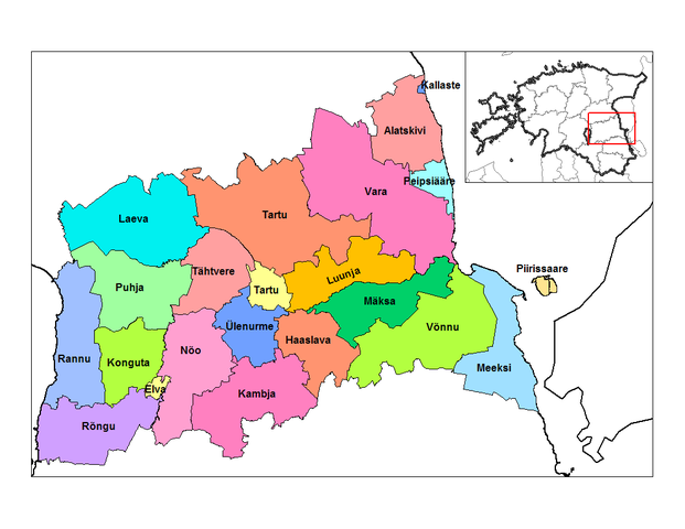
| Frágreiðing | Map of the municipalities of Tartu county in Estonia. Created by Rarelibra 17:36, 22 December 2006 (UTC) for public domain use, using MapInfo Professional v8.5 and various mapping resources. |
| Dagur | 22 desember 2006 (original upload date) |
| Kelda | No machine-readable source provided. Own work assumed (based on copyright claims). |
| Høvundur | No machine-readable author provided. Rarelibra assumed (based on copyright claims). |
Lisensur
| I, the copyright holder of this work, release this work into the public domain. This applies worldwide. In some countries this may not be legally possible; if so: I grant anyone the right to use this work for any purpose, without any conditions, unless such conditions are required by law. |
Søgan hjá fíluni
Trýst á dato/tíð fyri at síggja fíluna, sum hon sá út tá.
| Dagur/Tíð | Lítil mynd | Dimensjónir | Brúkari | Viðmerking | |
|---|---|---|---|---|---|
| streymur | 8. jan 2007 kl. 19:36 | | 1.056 × 816 (44 KB) | Rarelibra | Updated map due to 2006 changes. |
| 22. des 2006 kl. 17:36 |  | 1.056 × 816 (42 KB) | Rarelibra | Map of the municipalities of Tartu county in Estonia. Created by ~~~~ for public domain use, using MapInfo Professional v8.5 and various mapping resources. |
Myndarslóðir
Hesar síður slóða til hesa mynd:
Alheims fílunýtsla
Aðrar wkiir brúka hesa fílu:
- Nýtsla á ba.wikipedia.org
- Nýtsla á bs.wikipedia.org
- Nýtsla á en.wikipedia.org
- Nýtsla á es.wikipedia.org
- Nýtsla á fi.wikipedia.org
- Nýtsla á fr.wikipedia.org
- Nýtsla á gl.wikipedia.org
- Nýtsla á hu.wikipedia.org
- Nýtsla á it.wikipedia.org
- Nýtsla á ka.wikipedia.org
- Nýtsla á nn.wikipedia.org
- Nýtsla á no.wikipedia.org
- Nýtsla á pt.wikipedia.org
- Nýtsla á ro.wikipedia.org
- Nýtsla á ru.wikipedia.org
- Nýtsla á sco.wikipedia.org
- Nýtsla á sr.wikipedia.org
- Nýtsla á sv.wikipedia.org
- Nýtsla á uk.wikipedia.org
- Nýtsla á vi.wikipedia.org