
Mynd:Kalmarunionen.png
Ongin hægri upploysn varð funnin.
Kalmarunionen.png (540 × 238 pixel, stødd fílu: 70 KB, MIME-slag: image/png)

|
This historical map image could be re-created using vector graphics as an SVG file. This has several advantages; see Commons:Media for cleanup for more information. If an SVG form of this image is available, please upload it and afterwards replace this template with
{{vector version available|new image name}}.
It is recommended to name the SVG file “Kalmarunionen.svg”—then the template Vector version available (or Vva) does not need the new image name parameter. |
Samandráttur
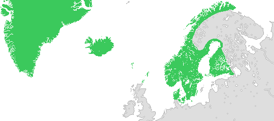
English: Map of the Kalmar union in 1397.
Changes made on 12 July 2012:
- More natural features, such as lakes.
- The southern border of Denmark has been moved northward (the duchies of Schleswig and Holstein weren't made a part of Denmark until 1460).
- The island of Gotland has been removed from the union (in 1396 it came into the hands of pirates and in 1398 it was taken over by the Teutonic Order, who didn't return it to the union until 1408).
- The northern borders of Sweden and Norway have been smoothed out (they were uncertain at this time and weren't drawn according to today's borders until the 17th and 18th centuries).
Svenska: Karta över Kalmarunionen 1397.
Ändringar gjorda 12 juli 2012:
- Fler geografiska delar, såsom sjöar.
- Danmarks sydgräns har flyttats norrut (hertigdömena Schleswig och Holstein blev inte delar av Danmark förrän 1460).
- Gotland har tagits bort från unionen (1396 hamnade ön i händerna på sjörövare och 1398 övertogs den av Tyska orden, som inte återlämnade den till unionen förrän 1408).
- Sveriges och Norges nordgränser har blivit utslätade (de var vid denna tid osäkra och drogs inte enligt nutida gränser förrän under 1600- och 1700-talen).
Lisensur
I, the copyright holder of this work, hereby publish it under the following licenses:

|
Loyvi verður givi at avrita, bera út og/ella broyta hetta skjal undir treytunum hjá GNU Free Documentation License, versión 1.2 ella einhvør seinni versjón ið er útgivin av Free Software Foundation; uttan nakað óbroytiligt brot, uttan forsíðutekst og uttan baksíðutekst. Eitt avrit av loyvinum er tikið við í brotinum ið nevnist GNU Free Documentation License. |
| Henda fíla er gjørd atkomulig undir Creative Commons Navngev-Deil á sama hátt 3.0 Unported loyvinum. | ||
| ||
| This licensing tag was added to this file as part of the GFDL licensing update. |
This file is licensed under the Creative Commons Attribution-Share Alike 2.5 Generic, 2.0 Generic and 1.0 Generic license.
- Tú ert vælkomin til:
- at deila – at avrita, breiða út og senda verkið
- at remiksa – at tillaga ella broyta verkið
- Undir hesum treytum:
- ognan – Tú mást ognarskrivað verkið á ein slíkan hátt sum er útgreinaður av høvundanum ella lisenseigaranum (men ikki á nakran hátt ið kundi bent á at hesin hevur góðkent teg ella tína nýtslu av verkinum).
- deil undir somu treytum – Um tú broytir, evnar til ella byggir víðari á hetta verk, so kanst tú bert útgeva verkið undir somu ella líkandi lisensi sum hesin.
Tú kanst velja tann lisens ið tú ynskir.
Søgan hjá fíluni
Trýst á dato/tíð fyri at síggja fíluna, sum hon sá út tá.
| Dagur/Tíð | Lítil mynd | Dimensjónir | Brúkari | Viðmerking | |
|---|---|---|---|---|---|
| streymur | 12. jul 2012 kl. 10:37 | | 540 × 238 (70 KB) | Ludde23 | Apparantly, that minor coastline fix wasn't fixed the last time, but now it is. |
| 12. jul 2012 kl. 10:33 |  | 540 × 238 (70 KB) | Ludde23 | Minor coastline fix. | |
| 12. jul 2012 kl. 10:16 |  | 540 × 238 (70 KB) | Ludde23 | A more accurate version of the map including: * More natural features, such as lakes. * The southern border of Denmark moved northward (the duchies of Schleswig and Holstein weren't made a part of Denmark until 1460). * The island of Gotland being r... | |
| 9. apr 2006 kl. 15:19 |  | 540 × 238 (8 KB) | Masae~commonswiki | The Kalmar Union in 1397 in green. |
Myndarslóðir
Hesar síður slóða til hesa mynd:
Alheims fílunýtsla
Aðrar wkiir brúka hesa fílu:
- Nýtsla á ast.wikipedia.org
- Nýtsla á bn.wikipedia.org
- Nýtsla á ca.wikipedia.org
- Nýtsla á da.wikipedia.org
- Nýtsla á el.wikipedia.org
- Nýtsla á en.wikipedia.org
- Nýtsla á eo.wikipedia.org
- Nýtsla á es.wikipedia.org
- Nýtsla á eu.wikipedia.org
- Nýtsla á hr.wikipedia.org
- Nýtsla á la.wikipedia.org
- Nýtsla á nn.wikipedia.org
- Nýtsla á no.wikipedia.org
- Nýtsla á pl.wikipedia.org
- Nýtsla á sv.wikipedia.org
- Nýtsla á zh.wikipedia.org