
Mynd:India-map-en.svg

Size of this PNG preview of this SVG file: 514 × 600 pixels. Aðrar upploysnir: 206 × 240 pixels | 411 × 480 pixels | 658 × 768 pixels | 877 × 1.024 pixels | 1.755 × 2.048 pixels | 1.519 × 1.773 pixels.
Upprunafíla (SVG fíle, nominelt 1.519 × 1.773 pixel, fíle stødd: 277 KB)
Ok ther are not anyone
Samandráttur
| Frágreiðing |
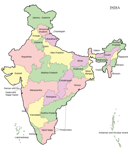
English: Map of India - states and union territories marked मराठी: भारताचा नकाशा हिन्दी : भारत का मानचित्र - राज्य और केंद्रशासित प्रदेश चिह्नित हैं বাংলা : ভারত দেশের মানচিত্র ਪੰਜਾਬੀ : ਭਾਰਤ ਦਾ ਨਕਸ਼ਾ ગુજરાતી : ભારતનો નકશો : રાજ્ય અને કેન્દ્રશાસિત પ્રદેશો ଓଡ଼ିଆ : ଭାରତ ମାନଚିତ୍ର தமிழ் : இந்தியாவின் வரைபடம் - மாநிலங்கள் மற்றும் யூனியன் பிரதேசங்கள் குறிக்கப்பட்டுள்ளன ಕನ್ನಡ : ಭಾರತದ ಭೂಪಟ മലയാളം : ഇന്ത്യയുടെ ഭൂപടം - സംസ്ഥാനങ്ങളും കേന്ദ്രഭരണപ്രദേശങ്ങളും അടയാളപ്പെടുത്തിയിരിക്കുന്നു اردو : بھارت کا نقشہ |
||
| Dagur | |||
| Kelda | Transferred from ml.wikipedia to Commons. | ||
| Høvundur | Rajeshodayanchal at malayalam Wikipedia. | ||
| Other versions |
[]
|


|
This SVG file contains embedded text that can be translated into your language, using any capable SVG editor, text editor or the SVG Translate tool. For more information see: About translating SVG files. |
Lisensur
This media file is uploaded with Malayalam loves Wikimedia event.
|
Rajeshodayanchal at malayalam Wikipedia, the copyright holder of this work, hereby publishes it under the following license:
Henda fíla er gjørd atkomulig undir Creative Commons Navngev-Deil á sama hátt 3.0 Unported loyvinum.
Ognan: Rajeshodayanchal at malayalam Wikipedia
- Tú ert vælkomin til:
- at deila – at avrita, breiða út og senda verkið
- at remiksa – at tillaga ella broyta verkið
- Undir hesum treytum:
- ognan – Tú mást ognarskrivað verkið á ein slíkan hátt sum er útgreinaður av høvundanum ella lisenseigaranum (men ikki á nakran hátt ið kundi bent á at hesin hevur góðkent teg ella tína nýtslu av verkinum).
- deil undir somu treytum – Um tú broytir, evnar til ella byggir víðari á hetta verk, so kanst tú bert útgeva verkið undir somu ella líkandi lisensi sum hesin.
Original upload log
This file was originally uploaded at ml.wikipedia as India-map-en.svg, before it was transfered to Commons.
Upload date | User | Bytes | Dimensions | Comment
- 4/10/2011 10:29:58 AM | Rajeshodayanchal | 277070 (bytes) | 1519×1773 | വിട്ടുപോയ കേന്ദ്രഭരണപ്രദേശങ്ങൾ കൂട്ടിച്ചേർക്കുന്നു
- 4/10/2011 2:28:09 AM | Rajeshodayanchal | 254531 (bytes) | 1519×1773 | {{വിവരങ്ങൾ |വിവരണം = ഇന്ത്യയുടെ ഭൂപടം - സംസ്ഥാനങ്ങളും കേന്ദ്രഭരണപ്രദേശങ്ങളും അടയാളപ്പെടുത്തി�
Søgan hjá fíluni
Trýst á dato/tíð fyri at síggja fíluna, sum hon sá út tá.
| Dagur/Tíð | Lítil mynd | Dimensjónir | Brúkari | Viðmerking | |
|---|---|---|---|---|---|
| streymur | 7. jun 2017 kl. 07:55 | | 1.519 × 1.773 (277 KB) | Rajeshodayanchal | Updated the map with a new state Telangana |
| 10. apr 2011 kl. 13:32 |  | 1.519 × 1.773 (271 KB) | Sreejithk2000 |
Myndarslóðir
Hesar síður slóða til hesa mynd:
Alheims fílunýtsla
Aðrar wkiir brúka hesa fílu:
- Nýtsla á af.wikipedia.org
- Nýtsla á bcl.wikipedia.org
- Nýtsla á bh.wikipedia.org
- Nýtsla á blk.wikipedia.org
- Nýtsla á bn.wikipedia.org
- Nýtsla á ca.wikipedia.org
- Nýtsla á de.wikipedia.org
- Nýtsla á dty.wikipedia.org
- Nýtsla á dv.wikipedia.org
- Nýtsla á en.wikipedia.org
- Nýtsla á es.wikipedia.org
- Nýtsla á fr.wikipedia.org
- Nýtsla á gom.wikipedia.org
- Nýtsla á gu.wikipedia.org
- Nýtsla á he.wikipedia.org
- Nýtsla á hif.wikipedia.org
- Nýtsla á hi.wikipedia.org
- Nýtsla á ilo.wikipedia.org
- Nýtsla á ja.wikipedia.org
- Nýtsla á ka.wikipedia.org
- Nýtsla á km.wikipedia.org
- Nýtsla á kn.wikipedia.org
- Nýtsla á mai.wikipedia.org
Vís meiri globala nýtslu av hesi fílu.