
Mynd:European settlements in India 1501-1739.png

Stødd av hesi forskoðan: 800 × 491 pixels. Aðrar upploysnir: 320 × 196 pixels | 640 × 393 pixels | 1.140 × 700 pixels.
Upprunafíla (1.140 × 700 pixel, stødd fílu: 168 KB, MIME-slag: image/png)
Samandráttur
| Frágreiðing |
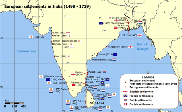
English: Map of India with Sri Lanka, illustrating locations of European settlements in the subcontinent between 1501 and 1739.
Norsk nynorsk: Kart over Sør-Asia med europeiske koloniar/busetjingar mellom 1501 og 1739.
Dansk: Kort af Indien inkl. Sri Lanka med europæiske kolonier mellem 1501 og 1739. |
| Dagur | uploaded in 2006 |
| Kelda |
Self-published work by Luis wiki Map reference: [1] at w:University of Pennsylvania, with reference varification from: [2] (URL accessed: 23-Mar-2006) |
| Høvundur | Luis wiki |
| Other versions |
|

![[1]](http://www.history.upenn.edu/coursepages/hist086/material/schmidt26a.jpg)

|
This map of asia image could be re-created using vector graphics as an SVG file. This has several advantages; see Commons:Media for cleanup for more information. If an SVG form of this image is available, please upload it and afterwards replace this template with
{{vector version available|new image name}}.
It is recommended to name the SVG file “European settlements in India 1501-1739.svg”—then the template Vector version available (or Vva) does not need the new image name parameter. |
Lisensur
I, the copyright holder of this work, hereby publish it under the following license:
This file is licensed under the Creative Commons Attribution-Share Alike 2.5 Generic license.
- Tú ert vælkomin til:
- at deila – at avrita, breiða út og senda verkið
- at remiksa – at tillaga ella broyta verkið
- Undir hesum treytum:
- ognan – Tú mást ognarskrivað verkið á ein slíkan hátt sum er útgreinaður av høvundanum ella lisenseigaranum (men ikki á nakran hátt ið kundi bent á at hesin hevur góðkent teg ella tína nýtslu av verkinum).
- deil undir somu treytum – Um tú broytir, evnar til ella byggir víðari á hetta verk, so kanst tú bert útgeva verkið undir somu ella líkandi lisensi sum hesin.
Søgan hjá fíluni
Trýst á dato/tíð fyri at síggja fíluna, sum hon sá út tá.
| Dagur/Tíð | Lítil mynd | Dimensjónir | Brúkari | Viðmerking | |
|---|---|---|---|---|---|
| streymur | 12. mar 2011 kl. 14:47 | | 1.140 × 700 (168 KB) | Luis wiki | Bombay, Portuguese from 1534, later on British |
| 5. feb 2011 kl. 22:30 |  | 1.140 × 700 (198 KB) | Henry Bottomley~commonswiki | Title date (see Calicut), Goa date, Flags of the time of Portugal, France and England | |
| 2. mar 2010 kl. 20:49 |  | 1.140 × 700 (158 KB) | Brianski | Fix spelling of "Portuguese" | |
| 22. feb 2007 kl. 20:34 |  | 1.140 × 700 (214 KB) | Wereon | "CE" unnecessary | |
| 23. mar 2006 kl. 12:32 |  | 1.140 × 700 (232 KB) | Miljoshi | Map of India with Sri Lanka, illustrating locations of European settlements in the subcontinent between 1501 and 1739 CE. Category:India |
Myndarslóðir
Hesar síður slóða til hesa mynd:
Alheims fílunýtsla
Aðrar wkiir brúka hesa fílu:
- Nýtsla á af.wikipedia.org
- Nýtsla á ar.wikipedia.org
- Nýtsla á ast.wikipedia.org
- Nýtsla á as.wikipedia.org
- Nýtsla á azb.wikipedia.org
- Nýtsla á az.wikipedia.org
- Nýtsla á bn.wikipedia.org
- Nýtsla á br.wikipedia.org
- Nýtsla á ca.wikipedia.org
- Nýtsla á cs.wikipedia.org
- Nýtsla á da.wikipedia.org
- Nýtsla á da.wikibooks.org
- Nýtsla á de.wikipedia.org
- Nýtsla á el.wikipedia.org
- Nýtsla á en.wikipedia.org
- Nýtsla á eo.wikipedia.org
- Nýtsla á es.wikipedia.org
Vís meiri globala nýtslu av hesi fílu.