
Mynd:Air Asia QZ8501 Flight Path and Satellite Imagery.jpg

Stødd av hesi forskoðan: 800 × 550 pixels. Aðrar upploysnir: 320 × 220 pixels | 640 × 440 pixels | 960 × 660 pixels.
Upprunafíla (960 × 660 pixel, stødd fílu: 300 KB, MIME-slag: image/jpeg)
Samandráttur
| Frágreiðing |
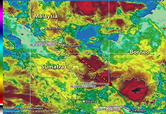
English: Flight path of Air Asia QZ8501 with Satellite Imagery on approx the time when the plane disappeared or lost contact. |
| Dagur | |
| Kelda |
Egið verk
The following materials were used for this upload:
|
| Høvundur | Chitetskoy |
Lisensur
I, the copyright holder of this work, hereby publish it under the following license:
This file is licensed under the Creative Commons Attribution-Share Alike 4.0 International license.
- Tú ert vælkomin til:
- at deila – at avrita, breiða út og senda verkið
- at remiksa – at tillaga ella broyta verkið
- Undir hesum treytum:
- ognan – Tú mást ognarskrivað verkið á ein slíkan hátt sum er útgreinaður av høvundanum ella lisenseigaranum (men ikki á nakran hátt ið kundi bent á at hesin hevur góðkent teg ella tína nýtslu av verkinum).
- deil undir somu treytum – Um tú broytir, evnar til ella byggir víðari á hetta verk, so kanst tú bert útgeva verkið undir somu ella líkandi lisensi sum hesin.
Søgan hjá fíluni
Trýst á dato/tíð fyri at síggja fíluna, sum hon sá út tá.
| Dagur/Tíð | Lítil mynd | Dimensjónir | Brúkari | Viðmerking | |
|---|---|---|---|---|---|
| streymur | 5. jan 2015 kl. 16:10 | | 960 × 660 (300 KB) | Chitetskoy | Added IR Color Scale for NOAA MTSAT-Rainbow Imagery as well as small label of the satimg timestamp. Sample can be found in this [url http://www.ssd.noaa.gov/mtsat/wpac/rb-l.jpg] which shows the MTSAT IR-Rainbow imagery focusing on Western Pacific area. |
| 28. des 2014 kl. 13:00 |  | 960 × 660 (295 KB) | Chitetskoy | More high resolution file | |
| 28. des 2014 kl. 12:57 |  | 960 × 660 (187 KB) | Chitetskoy | User created page with UploadWizard |
Myndarslóðir
Hesar síður slóða til hesa mynd:
Alheims fílunýtsla
Aðrar wkiir brúka hesa fílu:
- Nýtsla á bn.wikipedia.org
- Nýtsla á cs.wikipedia.org
- Nýtsla á da.wikipedia.org
- Nýtsla á en.wikipedia.org
- Nýtsla á es.wikipedia.org
- Nýtsla á hi.wikipedia.org
- Nýtsla á id.wikipedia.org
- Nýtsla á ja.wikipedia.org
- Nýtsla á ms.wikipedia.org
- Nýtsla á th.wikipedia.org
- Nýtsla á zh.wikipedia.org