
Mynd:African continent-en.svg

Size of this PNG preview of this SVG file: 635 × 600 pixels. Aðrar upploysnir: 254 × 240 pixels | 508 × 480 pixels | 813 × 768 pixels | 1.084 × 1.024 pixels | 2.169 × 2.048 pixels | 1.525 × 1.440 pixels.
Upprunafíla (SVG fíle, nominelt 1.525 × 1.440 pixel, fíle stødd: 752 KB)
| Frágreiðing |
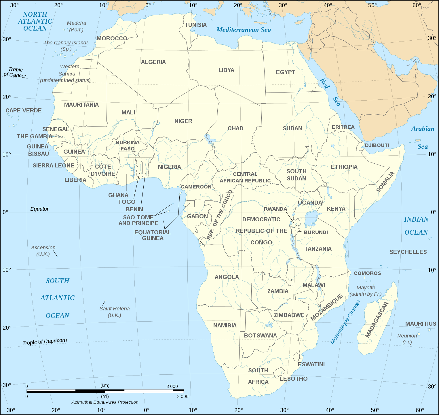
English: Map of the African continent as in 2011-07.
Français : Carte en anglais du continent africain tel qu'en 07/2011.
Lambert azimutal equal-area projection, WGS84 datum, standard meridian: 15°E, standard parallel: 0°Scale: 1:15,000,000 (accuracy: 3,75 km) |
||
| Dagur | (UTC), updated 2011-07 | ||
| Kelda | |||
| Høvundur |
|
||
| Other versions |
Derivative works of this file:
[]
Map close to Africa map political-fr.svg, but with some changes on the islands administrated by European countries and the Sinai peninsula |
||
| SVG genesis |
|


I, the copyright holder of this work, hereby publish it under the following license:
This file is licensed under the Creative Commons Attribution-Share Alike 2.5 Generic, 2.0 Generic and 1.0 Generic license.
- Tú ert vælkomin til:
- at deila – at avrita, breiða út og senda verkið
- at remiksa – at tillaga ella broyta verkið
- Undir hesum treytum:
- ognan – Tú mást ognarskrivað verkið á ein slíkan hátt sum er útgreinaður av høvundanum ella lisenseigaranum (men ikki á nakran hátt ið kundi bent á at hesin hevur góðkent teg ella tína nýtslu av verkinum).
- deil undir somu treytum – Um tú broytir, evnar til ella byggir víðari á hetta verk, so kanst tú bert útgeva verkið undir somu ella líkandi lisensi sum hesin.
Original upload log
This image is a derivative work of the following images:
- Image:Africa_map_blank.svg licensed with Cc-by-sa-2.5,2.0,1.0, Cc-by-sa-2.5,2.0,1.0/en
- 2008-06-27T03:34:58Z Sting 1525x1440 (711453 Bytes) Completely new drawing with known projection
- 2006-05-31T15:28:42Z Sting 1390x1295 (571519 Bytes) Enhanced version : African and Asian continents separated
- 2006-05-31T03:53:32Z Sting 1390x1295 (566642 Bytes) {{Information |Description=Blank vector graphic map of [[:Category:Maps of Africa|Africa]] |Source=Several bitmap-type maps |Date= May 2006 |Author= Eric Gaba ({{U|Sting}}) |Permission=GFDL or CC-BY-SA |other_version
Uploaded with derivativeFX
Søgan hjá fíluni
Trýst á dato/tíð fyri at síggja fíluna, sum hon sá út tá.
| Dagur/Tíð | Lítil mynd | Dimensjónir | Brúkari | Viðmerking | |
|---|---|---|---|---|---|
| streymur | 6. des 2020 kl. 18:21 | | 1.525 × 1.440 (752 KB) | Sting | Swatziland => eSwatini |
| 14. jul 2011 kl. 19:59 |  | 1.525 × 1.440 (752 KB) | Sting | Sudan/South Sudan 2011-07 border update | |
| 16. des 2010 kl. 16:42 |  | 1.525 × 1.440 (747 KB) | Sting | Spelling correction: Madeira | |
| 10. jan 2009 kl. 20:16 |  | 1.525 × 1.440 (747 KB) | Sting | Correction Sao Tome | |
| 6. des 2008 kl. 08:37 |  | 1.525 × 1.440 (750 KB) | Bobarino | {{Information |Description={{en|Map of the African continent.}} {{fr|Carte vierge du continent africain.}} Lambert azimutal equal-area projection, WGS84 datum, standard meridian: 15°E, standard pa |
Myndarslóðir
Ongar síður slóða til hesa myndina.
Alheims fílunýtsla
Aðrar wkiir brúka hesa fílu:
- Nýtsla á af.wikipedia.org
- Nýtsla á ar.wikipedia.org
- Nýtsla á azb.wikipedia.org
- Nýtsla á az.wiktionary.org
- Nýtsla á de.wikipedia.org
- Nýtsla á en.wikipedia.org
- Nýtsla á fa.wikipedia.org
- Nýtsla á hi.wikipedia.org
- Nýtsla á hu.wikibooks.org
- Nýtsla á id.wikipedia.org
- Nýtsla á ig.wikipedia.org
- Nýtsla á ilo.wikipedia.org
- Nýtsla á ja.wikipedia.org
- Nýtsla á ko.wikipedia.org
- Nýtsla á www.mediawiki.org
- Nýtsla á ml.wikipedia.org
- Nýtsla á mn.wikipedia.org
- Nýtsla á nl.wikipedia.org
- Nýtsla á sd.wikipedia.org
- Nýtsla á simple.wikipedia.org
- Nýtsla á sw.wikipedia.org
- Nýtsla á te.wikipedia.org
- Nýtsla á th.wikipedia.org
- Nýtsla á tr.wikipedia.org
- Nýtsla á uz.wikipedia.org
- Nýtsla á yo.wikipedia.org