
Mynd:Åland Political Map-en.svg

Size of this PNG preview of this SVG file: 595 × 600 pixels. Aðrar upploysnir: 238 × 240 pixels | 476 × 480 pixels | 762 × 768 pixels | 1.016 × 1.024 pixels | 2.032 × 2.048 pixels | 996 × 1.004 pixels.
Upprunafíla (SVG fíle, nominelt 996 × 1.004 pixel, fíle stødd: 219 KB)
Samandráttur
| Frágreiðing |
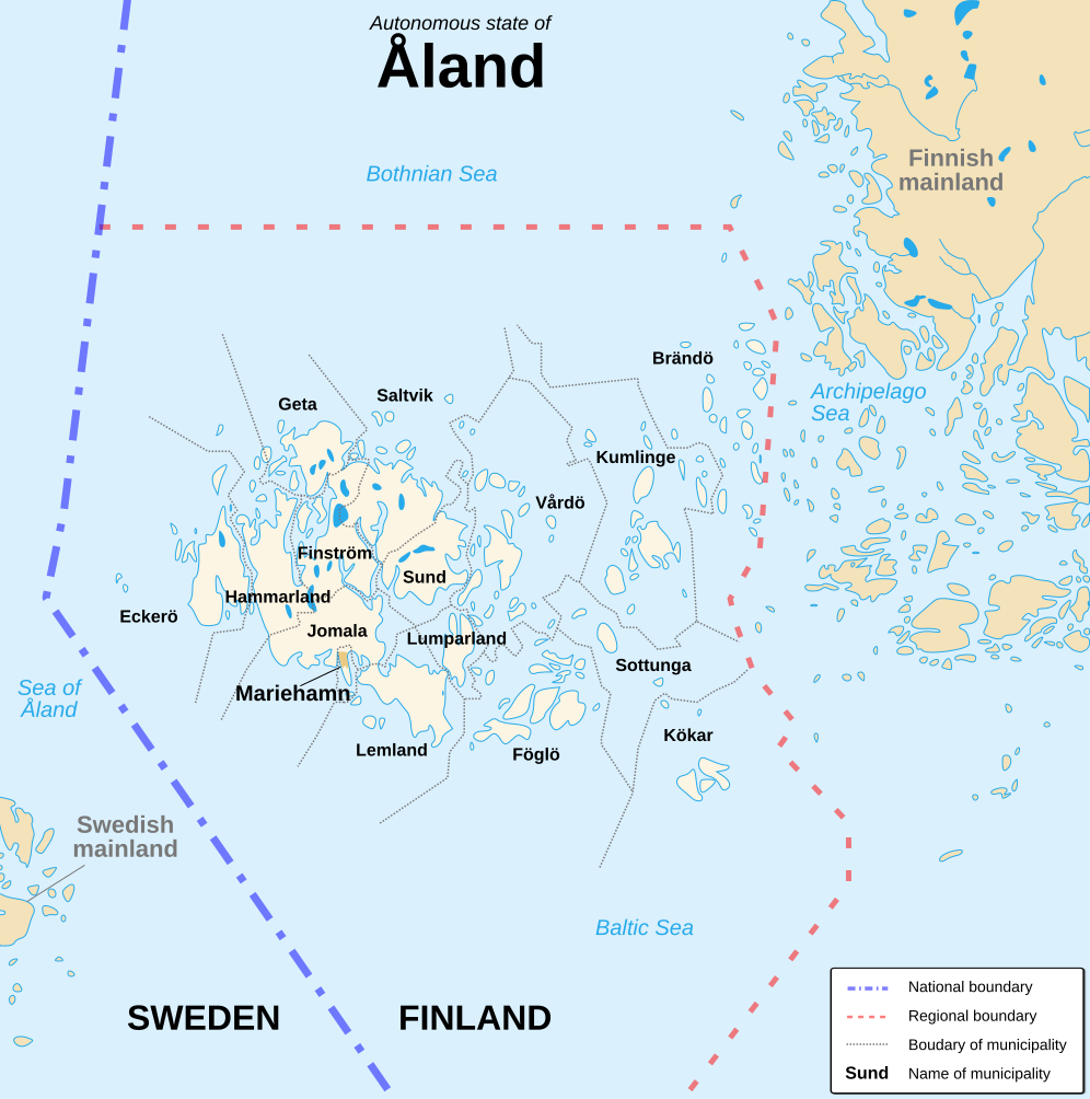
English: Political map of the autonomous finnish province of Åland, in english. Shows the national, regional and municipal boundaries about Åland islands. Français : Carte politique de l'État libre associé d'Åland, en anglais. La carte montre les frontières internationales, régionales et municipales concernant l'archipel d'Åland. |
||
| Dagur | |||
| Kelda |
English: Image:Alandmunicipalities.png and Image:Åland map.png, from Demis (see the approval e-mail and Demis forum). Français : Image:Alandmunicipalities.png et Image:Åland map.png, elles-même basées sur le site internet de Demis (voir le courriel d'autorisation et le forum de Demis). |
||
| Høvundur | Sémhur (talk) | ||
| Other versions |
|
||
| Ognan (required by the license) | © Sémhur / Wikimedia Commons / | ||
| SVG | W3C-validity not checked.
|
||
| Atelier graphique |

| Camera location | | View this and other nearby images on: OpenStreetMap |
|---|
Lisensur
I, the copyright holder of this work, hereby publish it under the following licenses:
| Copyleft: This work of art is free; you can redistribute it and/or modify it according to terms of the Free Art License. You will find a specimen of this license on the Copyleft Attitude site as well as on other sites. |
This file is licensed under the Creative Commons Attribution-Share Alike 4.0 International, 3.0 Unported, 2.5 Generic, 2.0 Generic and 1.0 Generic license.
- Tú ert vælkomin til:
- at deila – at avrita, breiða út og senda verkið
- at remiksa – at tillaga ella broyta verkið
- Undir hesum treytum:
- ognan – Tú mást ognarskrivað verkið á ein slíkan hátt sum er útgreinaður av høvundanum ella lisenseigaranum (men ikki á nakran hátt ið kundi bent á at hesin hevur góðkent teg ella tína nýtslu av verkinum).
- deil undir somu treytum – Um tú broytir, evnar til ella byggir víðari á hetta verk, so kanst tú bert útgeva verkið undir somu ella líkandi lisensi sum hesin.
Tú kanst velja tann lisens ið tú ynskir.
Søgan hjá fíluni
Trýst á dato/tíð fyri at síggja fíluna, sum hon sá út tá.
| Dagur/Tíð | Lítil mynd | Dimensjónir | Brúkari | Viðmerking | |
|---|---|---|---|---|---|
| streymur | 21. aug 2007 kl. 16:11 | | 996 × 1.004 (219 KB) | Sémhur | {{Information |Description=Political map of the autonomous finnish province of Åland, in english.<br/> Shows the national, regional and municipal boundaries about Åland islands. |Source=Own work. Based on Image:Alandmunicipalities.png and [[:Image: |
Myndarslóðir
Ongar síður slóða til hesa myndina.
Alheims fílunýtsla
Aðrar wkiir brúka hesa fílu:
- Nýtsla á ca.wikipedia.org
- Nýtsla á en.wikipedia.org
- Nýtsla á es.wikipedia.org
- Nýtsla á ga.wikipedia.org
- Nýtsla á gl.wikipedia.org
- Nýtsla á hy.wikipedia.org
- Nýtsla á li.wikipedia.org
- Nýtsla á nl.wikipedia.org
- Nýtsla á ru.wikipedia.org
- Nýtsla á www.wikidata.org