
Mynd:Koppen-Geiger Map ARG present.svg

Size of this PNG preview of this SVG file: 512 × 423 pixels. Aðrar upploysnir: 291 × 240 pixels | 581 × 480 pixels | 930 × 768 pixels | 1.240 × 1.024 pixels | 2.479 × 2.048 pixels.
Upprunafíla (SVG fíle, nominelt 512 × 423 pixel, fíle stødd: 1,21 MB)
Samandráttur
| Frágreiðing |
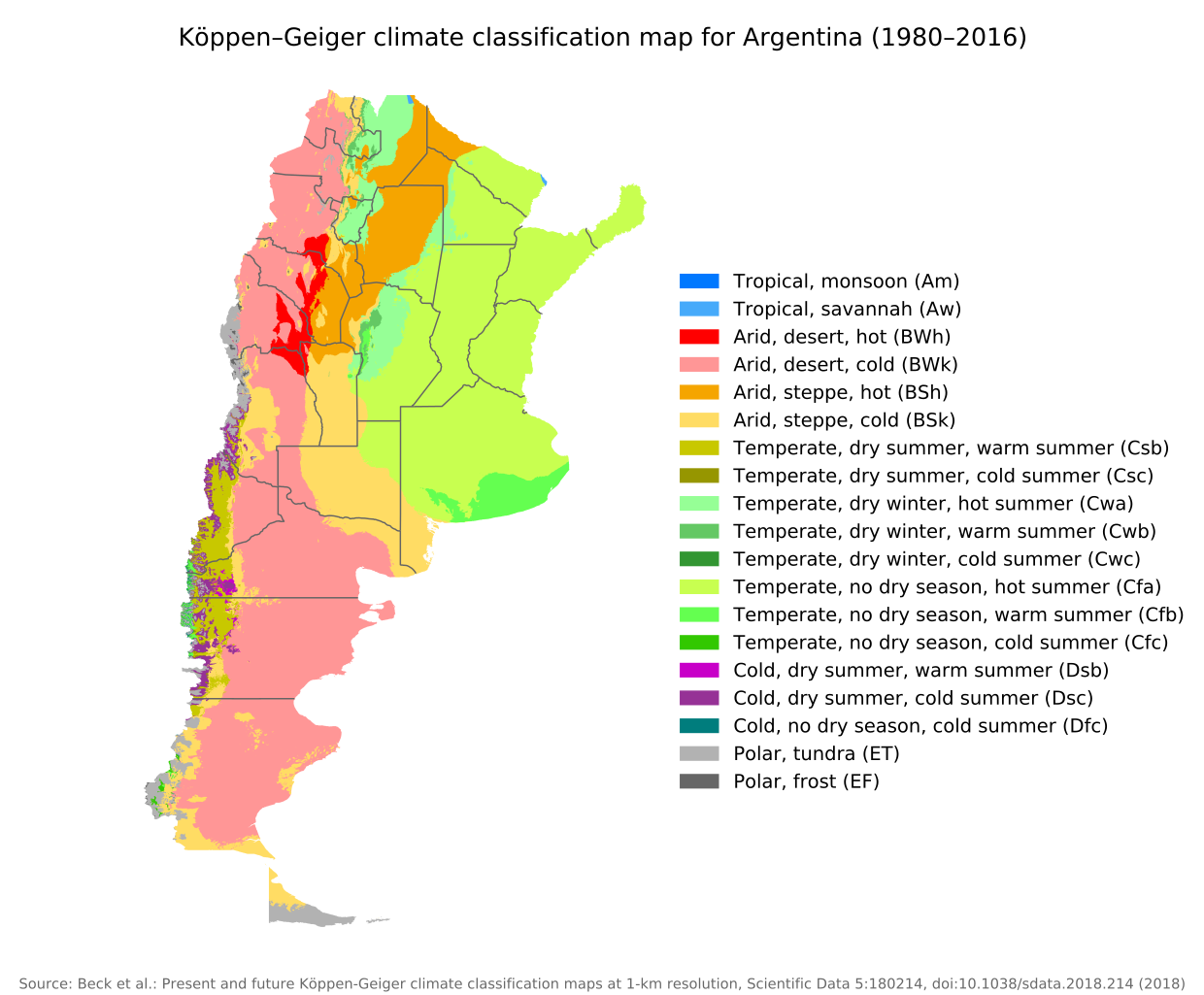
English: Köppen–Geiger climate classification map for Argentina |
| Dagur | |
| Kelda | "Present and future Köppen-Geiger climate classification maps at 1-km resolution". Nature Scientific Data. DOI:10.1038/sdata.2018.214. |
| Høvundur | Beck, H.E., Zimmermann, N. E., McVicar, T. R., Vergopolan, N., Berg, A., & Wood, E. F. |
Lisensur
This file is licensed under the Creative Commons Attribution 4.0 International license.
- Tú ert vælkomin til:
- at deila – at avrita, breiða út og senda verkið
- at remiksa – at tillaga ella broyta verkið
- Undir hesum treytum:
- ognan – Tú mást ognarskrivað verkið á ein slíkan hátt sum er útgreinaður av høvundanum ella lisenseigaranum (men ikki á nakran hátt ið kundi bent á at hesin hevur góðkent teg ella tína nýtslu av verkinum).
| Camera location | | View this and other nearby images on: OpenStreetMap |
|---|
Søgan hjá fíluni
Trýst á dato/tíð fyri at síggja fíluna, sum hon sá út tá.
| Dagur/Tíð | Lítil mynd | Dimensjónir | Brúkari | Viðmerking | |
|---|---|---|---|---|---|
| streymur | 8. sep 2020 kl. 09:14 | | 512 × 423 (1,21 MB) | Allice Hunter | Provinces and adjustments |
| 17. jul 2020 kl. 15:44 |  | 1.208 × 850 (1,51 MB) | JPLema | Reverted to version as of 21:36, 15 June 2020 (UTC) | |
| 17. jul 2020 kl. 15:43 |  | 840 × 812 (1,45 MB) | JPLema | reducción de tamaño | |
| 15. jun 2020 kl. 21:36 |  | 1.208 × 850 (1,51 MB) | JPLema | Reverted to version as of 03:03, 26 November 2018 (UTC) | |
| 15. jun 2020 kl. 13:02 |  | 696 × 1.006 (1,34 MB) | JPLema | reduje el ancho y aumenté la altura | |
| 26. nov 2018 kl. 03:03 |  | 1.208 × 850 (1,51 MB) | NVergopolan | {{Information |Description={{en| Köppen–Geiger climate classification map for Argentina}}|date=2018-11-06|source={{cite journal | journal=Nature Scientific Data |doi=10.1038/sdata.2018.214}}|author=Beck, H.E., Zimmermann, N. E., McVicar, T. R., Vergopolan, N., Berg, A., & Wood, E. F.|permission=|other_versions=|other_fields=}}{{Cc-by-4.0}}{{Location|-38.42003918|-63.58480835}}Category:Köppen-Geiger Climate Classification MapsCategory:present climate (1980–2016)Category:Argentina[[... |
Myndarslóðir
Ongar síður slóða til hesa myndina.
Alheims fílunýtsla
Aðrar wkiir brúka hesa fílu:
- Nýtsla á bg.wikipedia.org
- Nýtsla á ckb.wikipedia.org
- Nýtsla á en.wikipedia.org
- Nýtsla á id.wikipedia.org
- Nýtsla á ja.wikipedia.org
- Nýtsla á km.wikipedia.org
- Nýtsla á pt.wikipedia.org
- Nýtsla á ru.wikipedia.org
- Nýtsla á sr.wikipedia.org
- Nýtsla á tr.wikipedia.org
- Nýtsla á uk.wikipedia.org