
Mynd:Mercator Septentrionalium Terrarum descriptio.jpg
Stødd av hesi forskoðan: 646 × 599 pixels. Aðrar upploysnir: 259 × 240 pixels | 517 × 480 pixels | 828 × 768 pixels | 1.104 × 1.024 pixels | 2.208 × 2.048 pixels | 3.261 × 3.025 pixels.
Upprunafíla (3.261 × 3.025 pixel, stødd fílu: 3,04 MB, MIME-slag: image/jpeg)
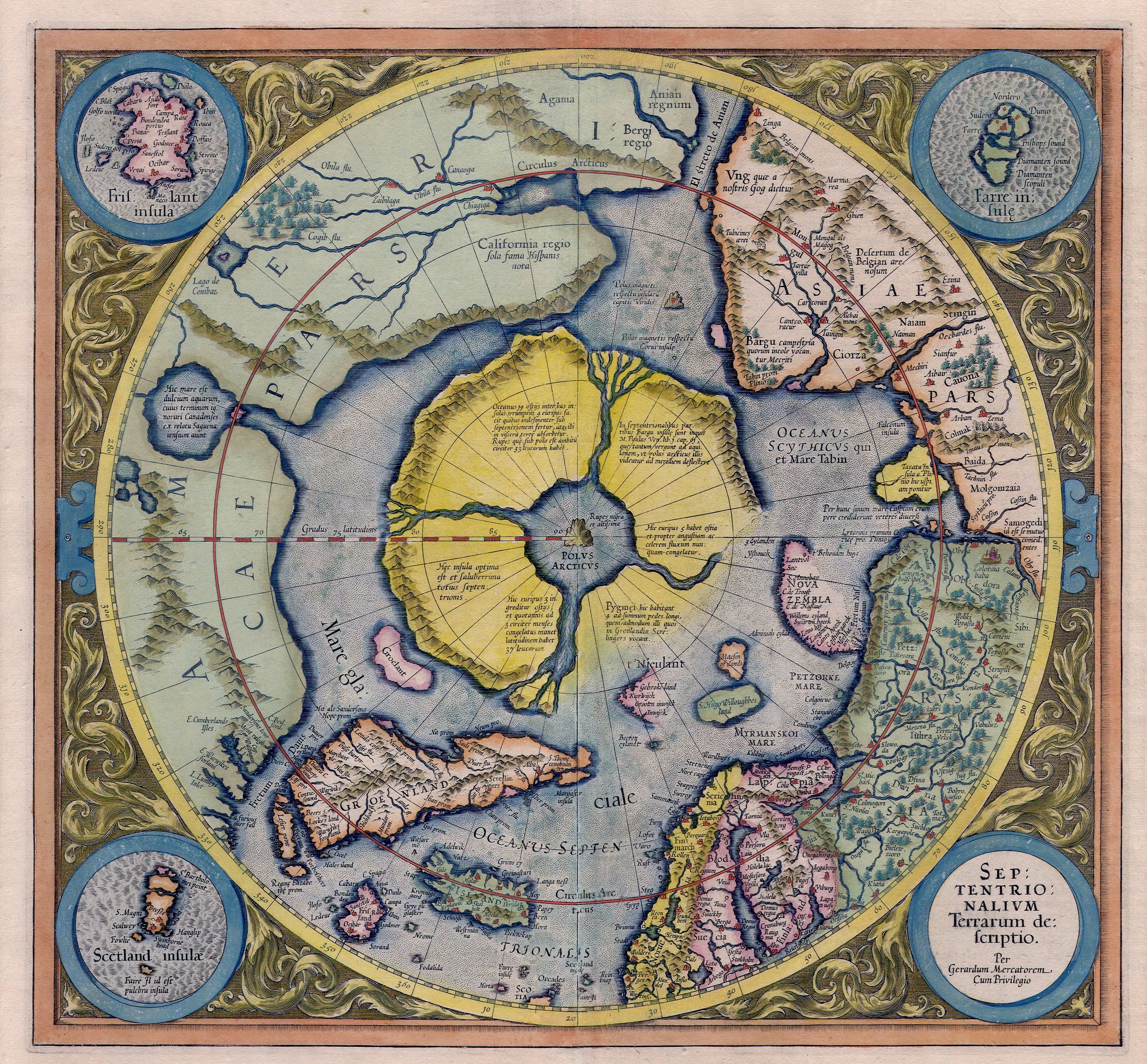
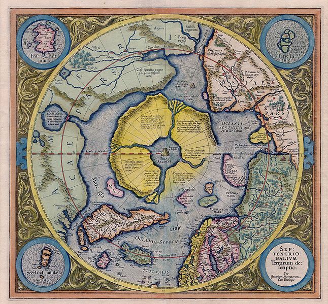
| Frágreiðing | Mercator: Septentrionalium Terrarum descriptio. A map of the North Pole. |
| Dagur | |
| Kelda | Helmink Antique Maps |
| Høvundur | Gerardus Mercator, with addition of data from Willem Barentsz voyages |
| Loyvi (Endurnýtsla av hesi fílu) |
PD because of age |
|
This work is in the public domain in its country of origin and other countries and areas where the copyright term is the author's life plus 100 years or fewer. | |
| This file has been identified as being free of known restrictions under copyright law, including all related and neighboring rights. | |
| Annotations | This image is annotated: View the annotations at Commons |
Søgan hjá fíluni
Trýst á dato/tíð fyri at síggja fíluna, sum hon sá út tá.
| Dagur/Tíð | Lítil mynd | Dimensjónir | Brúkari | Viðmerking | |
|---|---|---|---|---|---|
| streymur | 6. mai 2007 kl. 10:13 | | 3.261 × 3.025 (3,04 MB) | Jan Arkesteijn | {{Information |Description=Mercator: Septentrionalium Terrarum descriptio. A map of the northpole. |Source=[http://www.helmink.com/Antique_Map_Mercator_Arctic/ Helmink Antique Maps] |Date=1595 - 1623 |Author=Gerardus Mercator |Permission=PD because of age |
Myndarslóðir
Ongar síður slóða til hesa myndina.
Alheims fílunýtsla
Aðrar wkiir brúka hesa fílu:
- Nýtsla á bg.wikipedia.org
- Nýtsla á cs.wikipedia.org
- Nýtsla á cv.wikipedia.org
- Nýtsla á de.wikipedia.org
- Nýtsla á en.wikipedia.org
- Nýtsla á eo.wikipedia.org
- Nýtsla á es.wikipedia.org
- Nýtsla á fi.wikipedia.org
- Käyttäjä:Johannes sankari
- Wikipedia:Käyttäjälaatikot/Aihealueet
- Malline:Käyttäjä Mytologiat
- Käyttäjä:Oan
- Käyttäjä:DLS
- Käyttäjä:Elenloth
- Käyttäjä:Mstislav Ivanovich
- Käyttäjä:Mikko95
- Käyttäjä:Butthead Rotten
- Käyttäjä:Fengshuimestari
- Käyttäjä:Heinasirkka
- Käyttäjä:IruPiru
- Käyttäjä:101090ABC/Käyttäjälaatikot ja kielitaito
- Käyttäjä:Rougar
- Käyttäjä:Röhmöfantti
- Käyttäjä:Zemant
- Käyttäjä:Capisce~fiwiki
- Käyttäjä:Ilarius
- Käyttäjä:Dragomir~fiwiki
- Käyttäjä:Veera Verbi
- Käyttäjä:Saijanurmi
- Käyttäjä:Mumintrollet202
- Käyttäjä:PowerBUL
- Käyttäjä:Jyri Nieminen
- Käyttäjä:Luurankosoturi
- Käyttäjä:Talvipäivänseisaus
- Käyttäjä:Aenoran
- Nýtsla á fr.wikipedia.org
- Nýtsla á hu.wikipedia.org
- Nýtsla á hy.wikipedia.org
- Nýtsla á id.wikipedia.org
- Nýtsla á is.wikipedia.org
- Nýtsla á it.wikipedia.org
Vís meiri globala nýtslu av hesi fílu.