
Mynd:Karte Eysturoyartunnilin.svg

Size of this PNG preview of this SVG file: 652 × 599 pixels. Aðrar upploysnir: 261 × 240 pixels | 522 × 480 pixels | 836 × 768 pixels | 1.114 × 1.024 pixels | 2.229 × 2.048 pixels | 1.271 × 1.168 pixels.
Upprunafíla (SVG fíle, nominelt 1.271 × 1.168 pixel, fíle stødd: 616 KB)
Samandráttur
| Frágreiðing |
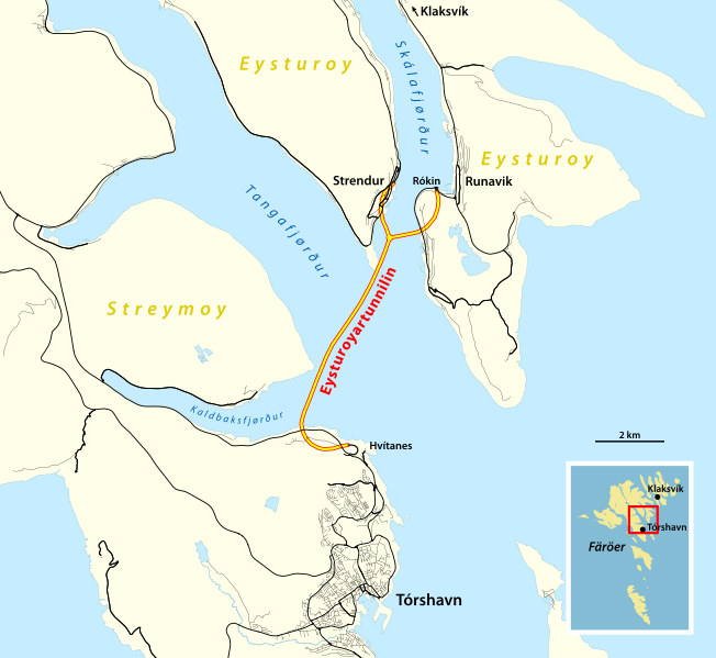
Deutsch: Karte des Eysturoyartunnilin |
|||
| Dagur | ||||
| Kelda |
Own work using:
|
|||
| Høvundur | NordNordWest |

|
This map has been made or improved in the German Kartenwerkstatt (Map Lab). You can propose maps to improve as well.
|
Lisensur
I, the copyright holder of this work, hereby publish it under the following license:
This file is licensed under the Creative Commons Attribution-Share Alike 2.0 Generic license.
- Tú ert vælkomin til:
- at deila – at avrita, breiða út og senda verkið
- at remiksa – at tillaga ella broyta verkið
- Undir hesum treytum:
- ognan – Tú mást ognarskrivað verkið á ein slíkan hátt sum er útgreinaður av høvundanum ella lisenseigaranum (men ikki á nakran hátt ið kundi bent á at hesin hevur góðkent teg ella tína nýtslu av verkinum).
- deil undir somu treytum – Um tú broytir, evnar til ella byggir víðari á hetta verk, so kanst tú bert útgeva verkið undir somu ella líkandi lisensi sum hesin.
Søgan hjá fíluni
Trýst á dato/tíð fyri at síggja fíluna, sum hon sá út tá.
| Dagur/Tíð | Lítil mynd | Dimensjónir | Brúkari | Viðmerking | |
|---|---|---|---|---|---|
| streymur | 21. des 2020 kl. 17:52 | | 1.271 × 1.168 (616 KB) | NordNordWest | == {{int:filedesc}} == {{Information |description= {{de|1=Karte des Eysturoyartunnilin}} |source={{Own using}} * [http://www.openstreetmap.org/ OpenStreetMap] data {{ODbL OpenStreetMap}} |date=2020-12-21 |author={{U|NordNordWest}} |permission= |other_versions= }} {{Kartenwerkstatt}} == {{int:license-header}} == {{self|cc-by-sa-2.0}} Category:Eysturoyartunnilin Category:SVG maps of the Faroe Islands Category:Files by NordNordWest 0map, 2017 [[Catego... |
Myndarslóðir
Hesar síður slóða til hesa mynd:
Alheims fílunýtsla
Aðrar wkiir brúka hesa fílu:
- Nýtsla á ca.wikipedia.org
- Nýtsla á cs.wikipedia.org
- Nýtsla á de.wikipedia.org
- Nýtsla á hu.wikipedia.org
- Nýtsla á is.wikipedia.org
- Nýtsla á it.wikipedia.org
- Nýtsla á nl.wikipedia.org
- Nýtsla á sv.wikipedia.org
- Nýtsla á uk.wikipedia.org
- Nýtsla á www.wikidata.org
- Nýtsla á zh.wikipedia.org