
Mynd:Hanstholmen-map.png

Upprunafíla (2.260 × 1.557 pixel, stødd fílu: 1,14 MB, MIME-slag: image/png)
Samandráttur
Source: http://en.wikipedia.org/wiki/Image:Hanstholmen-map.png
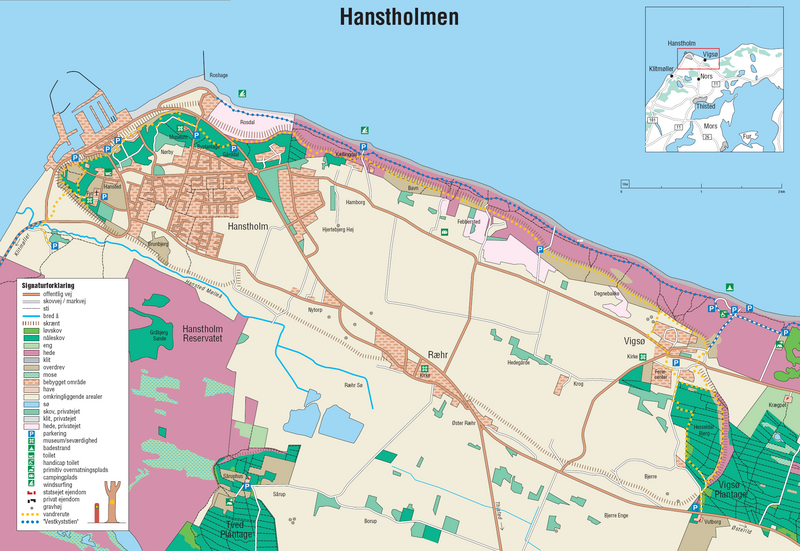
A detailed map of Hanstholm. From the brochure "Vandreture nr. 118. Hanstholmen", updated January 2005, published by the Danish Forest and Nature Agency. The dashed lines indicate a very steep slope, the former coastline.
Lisensur
Under the case number "J.nr. SN 2001-0650-0003", where Lars Dybdahl requested permission to use this map with Wikipedia, the case was handled by the responsible person Pia Bøttiger Andersen from the Danish Ministry of the Environment, on the date 2005-12-20. The response was, that the Danish Forest and Nature Agency has permitted the use of this map for general use, as long as a reference to the source is given. This is an example of such a reference is in Danish:
- Fra Skov- og Naturstyrelsens folder "Vandreture nr. 118. Hanstholmen (opdateret januar 2005).
This translates into:
- From the Danish Forest and Nature Agency brochure "Vandreture nr. 118. Hanstholmen" (updated January 2005)
The official homepage of the agency is: www.skovognatur.dk Official email address of the agency is: sns@sns.dk
- Tú ert vælkomin til:
- at deila – at avrita, breiða út og senda verkið
- at remiksa – at tillaga ella broyta verkið
- Undir hesum treytum:
- ognan – Tú mást ognarskrivað verkið á ein slíkan hátt sum er útgreinaður av høvundanum ella lisenseigaranum (men ikki á nakran hátt ið kundi bent á at hesin hevur góðkent teg ella tína nýtslu av verkinum).
- deil undir somu treytum – Um tú broytir, evnar til ella byggir víðari á hetta verk, so kanst tú bert útgeva verkið undir somu ella líkandi lisensi sum hesin.
Søgan hjá fíluni
Trýst á dato/tíð fyri at síggja fíluna, sum hon sá út tá.
| Dagur/Tíð | Lítil mynd | Dimensjónir | Brúkari | Viðmerking | |
|---|---|---|---|---|---|
| streymur | 27. jun 2006 kl. 17:45 | | 2.260 × 1.557 (1,14 MB) | Igiveup | == Summary == Source: http://en.wikipedia.org/wiki/Image:Hanstholmen-map.png A detailed map of Hanstholm. From the brochure "Vandreture nr. 118. Hanstholmen", updated January 2005, published by [http://www.sns.dk/ the Danish Forest and Nature Agency]. T |
Myndarslóðir
Hesar síður slóða til hesa mynd:
Alheims fílunýtsla
Aðrar wkiir brúka hesa fílu: