
Mynd:Glostrup Kommune raadhus oestfloej.JPG

Stødd av hesi forskoðan: 800 × 600 pixels. Aðrar upploysnir: 320 × 240 pixels | 640 × 480 pixels | 1.024 × 768 pixels | 1.280 × 960 pixels | 2.048 × 1.536 pixels.
Upprunafíla (2.048 × 1.536 pixel, stødd fílu: 1,36 MB, MIME-slag: image/jpeg)
| Frágreiðing |
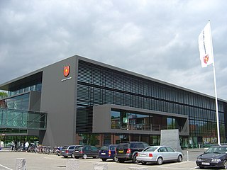
English: Glostrup Rådhus - One of the buildings for the town hall (east wing) in Glostrup, Copenhagen. Seen from south side, on the road called Rådhusparken.
Dansk: Glostrup Rådhus - En af bygningerne tilknyttet rådhuset (østfløjen) i Glostrup, København. Set fra den sydlige side, på vejen kaldet Rådhusparken. |
| Dagur | |
| Kelda | Egið verk |
| Høvundur | Froztbyte |
| Loyvi (Endurnýtsla av hesi fílu) |
Attribution required: This illustration was created by Froztbyte (e-mail me) If you use this illustration outside the Wikimedia projects please credit this way: © www.mysona.dk I, the copyright holder of this work, hereby publish it under the following license: Henda fíla er gjørd atkomulig undir Creative Commons Navngev-Deil á sama hátt 3.0 Unported loyvinum.
|
| Camera location | | View this and other nearby images on: OpenStreetMap |
|---|
Søgan hjá fíluni
Trýst á dato/tíð fyri at síggja fíluna, sum hon sá út tá.
| Dagur/Tíð | Lítil mynd | Dimensjónir | Brúkari | Viðmerking | |
|---|---|---|---|---|---|
| streymur | 26. nov 2008 kl. 03:21 | | 2.048 × 1.536 (1,36 MB) | Froztbyte | {{Information |Description={{en|1='''Glostrup Rådhus''' - One of the buildings for the town hall (east wing) in Glostrup, Copenhagen. Seen from south side, on the road called ''Rådhusparken''.}} {{da|1='''[[w:da:Glostrup K |
Myndarslóðir
Hesar síður slóða til hesa mynd:
Alheims fílunýtsla
Aðrar wkiir brúka hesa fílu:
- Nýtsla á ar.wikipedia.org
- Nýtsla á ast.wikipedia.org
- Nýtsla á bg.wikipedia.org
- Nýtsla á da.wikipedia.org
- Nýtsla á de.wikipedia.org
- Nýtsla á en.wikipedia.org
- Nýtsla á es.wikipedia.org
- Nýtsla á frr.wikipedia.org
- Nýtsla á fr.wikipedia.org
- Nýtsla á ka.wikipedia.org
- Nýtsla á lv.wikipedia.org
- Nýtsla á ms.wikipedia.org
- Nýtsla á nl.wikipedia.org
- Nýtsla á no.wikipedia.org
- Nýtsla á pl.wikipedia.org
- Nýtsla á pt.wikipedia.org
- Nýtsla á ru.wikipedia.org
- Nýtsla á sv.wikipedia.org
- Nýtsla á szl.wikipedia.org
- Nýtsla á tr.wikipedia.org
- Nýtsla á uk.wikipedia.org
- Nýtsla á ur.wikipedia.org
- Nýtsla á uz.wikipedia.org
- Nýtsla á www.wikidata.org
- Nýtsla á zh.wikipedia.org