
Mynd:British Islands.svg

Size of this PNG preview of this SVG file: 343 × 600 pixels. Aðrar upploysnir: 137 × 240 pixels | 274 × 480 pixels | 439 × 768 pixels | 586 × 1.024 pixels | 1.171 × 2.048 pixels | 675 × 1.180 pixels.
Upprunafíla (SVG fíle, nominelt 675 × 1.180 pixel, fíle stødd: 243 KB)
Samandráttur
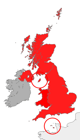
| Frágreiðing | map showing the territory referred to as "the British Islands" in relation to Great Britain and Ireland (namely the United Kingdom plus the Crown Dependencies, but not the Republic of Ireland) |
| Dagur | |
| Kelda | Egið verk |
| Høvundur | Cnbrb |
| SVG genesis |
Lisensur
| I, the copyright holder of this work, release this work into the public domain. This applies worldwide. In some countries this may not be legally possible; if so: I grant anyone the right to use this work for any purpose, without any conditions, unless such conditions are required by law. |
Søgan hjá fíluni
Trýst á dato/tíð fyri at síggja fíluna, sum hon sá út tá.
| Dagur/Tíð | Lítil mynd | Dimensjónir | Brúkari | Viðmerking | |
|---|---|---|---|---|---|
| streymur | 28. okt 2016 kl. 12:45 | | 675 × 1.180 (243 KB) | Smyth | Highlight crown dependencies, otherwise map looks identical to File:British Isles United Kingdom.svg at small sizes. |
| 20. okt 2007 kl. 21:32 |  | 675 × 1.180 (241 KB) | Cnbrb | == Summary == {{Information |Description=map showing the territory referred to as "the British Islands" in relation to Great Britain and Ireland (namely the United Kingdom plus the Crown Dependencies, but not the Republic of Ireland) |Source=self-made |Da |
Myndarslóðir
Ongar síður slóða til hesa myndina.
Alheims fílunýtsla
Aðrar wkiir brúka hesa fílu:
- Nýtsla á cs.wikipedia.org
- Nýtsla á en.wikipedia.org
- Nýtsla á es.wikipedia.org
- Nýtsla á fa.wikipedia.org
- Nýtsla á fr.wiktionary.org
- Nýtsla á he.wikipedia.org
- Nýtsla á hu.wikipedia.org
- Nýtsla á id.wikipedia.org
- Nýtsla á it.wikipedia.org
- Nýtsla á kk.wikipedia.org
- Nýtsla á lt.wikipedia.org
- Nýtsla á ru.wikipedia.org
- Nýtsla á si.wikipedia.org
- Nýtsla á sr.wikipedia.org
- Nýtsla á sv.wikipedia.org
- Nýtsla á tr.wikipedia.org
- Nýtsla á uk.wikipedia.org
- Nýtsla á vi.wikipedia.org
- Nýtsla á zh.wikipedia.org