
Mynd:Bhutan-divisions-numbered.png
Ongin hægri upploysn varð funnin.
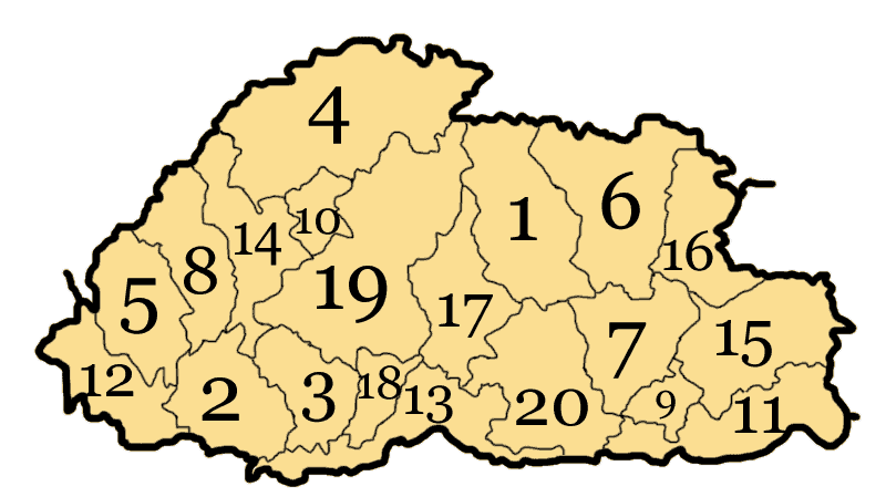
Bhutan-divisions-numbered.png (800 × 449 pixel, stødd fílu: 20 KB, MIME-slag: image/png)
Bhutan subdivisions numbered
Drawn by me, Nichalp
| I, the copyright holder of this work, release this work into the public domain. This applies worldwide. In some countries this may not be legally possible; if so: I grant anyone the right to use this work for any purpose, without any conditions, unless such conditions are required by law. |

|
This locator map image could be re-created using vector graphics as an SVG file. This has several advantages; see Commons:Media for cleanup for more information. If an SVG form of this image is available, please upload it and afterwards replace this template with
{{vector version available|new image name}}.
It is recommended to name the SVG file “Bhutan-divisions-numbered.svg”—then the template Vector version available (or Vva) does not need the new image name parameter. |
derivative works
Derivative works of this file:
Søgan hjá fíluni
Trýst á dato/tíð fyri at síggja fíluna, sum hon sá út tá.
| Dagur/Tíð | Lítil mynd | Dimensjónir | Brúkari | Viðmerking | |
|---|---|---|---|---|---|
| streymur | 10. aug 2005 kl. 05:38 | | 800 × 449 (20 KB) | Nichalp | correcting error |
| 8. aug 2005 kl. 19:05 |  | 800 × 449 (18 KB) | Nichalp | Bhutan subdivisions numbered Drawn by me, ~~~ {{PD-self}} category:Maps of Bhutan |
Myndarslóðir
Hesar síður slóða til hesa mynd:
Alheims fílunýtsla
Aðrar wkiir brúka hesa fílu:
- Nýtsla á ar.wikipedia.org
- Nýtsla á azb.wikipedia.org
- Nýtsla á bo.wikipedia.org
- Nýtsla á br.wikipedia.org
- Nýtsla á cv.wikipedia.org
- Nýtsla á da.wikipedia.org
- Nýtsla á de.wikipedia.org
- Nýtsla á dv.wikipedia.org
- Nýtsla á en.wikipedia.org
- Nýtsla á es.wikipedia.org
- Nýtsla á fi.wikipedia.org
- Nýtsla á fr.wikipedia.org
- Nýtsla á he.wikipedia.org
- Nýtsla á id.wikipedia.org
- Nýtsla á ja.wikipedia.org
- Nýtsla á ko.wikipedia.org
- Nýtsla á ku.wikipedia.org
- Nýtsla á lt.wikipedia.org
- Nýtsla á nl.wikipedia.org
- Nýtsla á no.wikipedia.org
- Nýtsla á pl.wikipedia.org
- Nýtsla á pl.wikivoyage.org
- Nýtsla á ro.wikipedia.org
- Nýtsla á sq.wikipedia.org
- Nýtsla á sr.wikipedia.org
- Nýtsla á trv.wikipedia.org
- Nýtsla á vi.wikipedia.org