
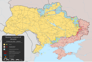
Mynd:2022 Russian invasion of Ukraine.svg

Upprunafíla (SVG fíle, nominelt 2.199 × 1.478 pixel, fíle stødd: 3,72 MB)
Rules for editing the map
|
| All edit warring, adding of unsourced information or performing a color change without consensus may result in the user being blocked. All contributions should first be discussed on the talk page. |
Samandráttur

|
This file may be updated to reflect new information. If you wish to use a specific version of the file without new updates being mirrored, please upload the required version as a separate file. |
| Frágreiðing | |||
| Dagur | 24 februar 2022 (first version) | ||
| Kelda |
Own work based on: Russo-Ukrainian conflict (2014-2022).svg by Rr016 & Ukraine adm location map improved.svg by Yakiv Gluck
|
||
| Høvundur | Viewsridge | ||
| Other versions |
[]
|
||
| SVG genesis | This map is translated using SVG switch elements: all translations are stored in the same file.
|


.gif)

.gif)


_en.png)
_vi.png)
_ru.png)
.svg)
This file is translated using SVG <switch> elements. All translations are stored in the same file! Learn more.
For most Wikipedia projects, you can embed the file normally (without a To translate the text into your language, you can use the SVG Translate tool. Alternatively, you can download the file to your computer, add your translations using whatever software you're familiar with, and re-upload it with the same name. You will find help in Graphics Lab if you're not sure how to do this. |
Lisensur
- Tú ert vælkomin til:
- at deila – at avrita, breiða út og senda verkið
- at remiksa – at tillaga ella broyta verkið
- Undir hesum treytum:
- ognan – Tú mást ognarskrivað verkið á ein slíkan hátt sum er útgreinaður av høvundanum ella lisenseigaranum (men ikki á nakran hátt ið kundi bent á at hesin hevur góðkent teg ella tína nýtslu av verkinum).
- deil undir somu treytum – Um tú broytir, evnar til ella byggir víðari á hetta verk, so kanst tú bert útgeva verkið undir somu ella líkandi lisensi sum hesin.
Søgan hjá fíluni
Trýst á dato/tíð fyri at síggja fíluna, sum hon sá út tá.
| Dagur/Tíð | Lítil mynd | Dimensjónir | Brúkari | Viðmerking | |
|---|---|---|---|---|---|
| streymur | 16. mai 2024 kl. 20:47 | | 2.199 × 1.478 (3,72 MB) | Physeters | Updates in Kharkiv Oblast per the ISW |
| 14. mai 2024 kl. 04:40 |  | 2.199 × 1.478 (3,72 MB) | Physeters | fix Derhachi | |
| 13. mai 2024 kl. 05:36 |  | 2.199 × 1.478 (3,72 MB) | Alexiscoutinho | Updated Vovchansk per detailed map | |
| 13. mai 2024 kl. 02:49 |  | 2.199 × 1.478 (3,72 MB) | Physeters | Updates per the ISW; for future reference, sources (like SuriyakMaps) must first have their reliability vetted on the talk page before they can be used to update the map; at the moment, the only two verified sources are the ISW and the Detailed Map on Wikipedia | |
| 12. mai 2024 kl. 10:34 |  | 2.199 × 1.478 (3,31 MB) | BlackShadowG | File uploaded using svgtranslate tool (https://svgtranslate.toolforge.org/). Added translation for zh-tw. | |
| 12. mai 2024 kl. 08:46 |  | 2.199 × 1.478 (3,31 MB) | Miki1234568 | File uploaded using svgtranslate tool (https://svgtranslate.toolforge.org/). Added translation for pl. | |
| 12. mai 2024 kl. 07:54 |  | 2.199 × 1.478 (3,31 MB) | BlackShadowG | File uploaded using svgtranslate tool (https://svgtranslate.toolforge.org/). Added translation for zh-cn. | |
| 11. mai 2024 kl. 23:02 |  | 2.199 × 1.478 (3,71 MB) | Mattia332 | As per Renowned Unbiased Open Source "SuriyakMaps", Russian progress in Kharkov | |
| 10. mai 2024 kl. 19:38 |  | 2.199 × 1.478 (3,71 MB) | Physeters | add date marker | |
| 10. mai 2024 kl. 19:31 |  | 2.199 × 1.478 (3,71 MB) | Physeters | Update per the ISW; Russia re-enters northern Kharkiv Oblast |
Myndarslóðir
Hesar síður slóða til hesa mynd:
Alheims fílunýtsla
Aðrar wkiir brúka hesa fílu:
- Nýtsla á af.wikipedia.org
- Nýtsla á als.wikipedia.org
- Nýtsla á am.wikipedia.org
- Nýtsla á ang.wikipedia.org
- Nýtsla á an.wikipedia.org
- Nýtsla á ar.wikipedia.org
- Nýtsla á ary.wikipedia.org
- Nýtsla á arz.wikipedia.org
- Nýtsla á ast.wikipedia.org
- Nýtsla á azb.wikipedia.org
- Nýtsla á az.wikipedia.org
- Nýtsla á bat-smg.wikipedia.org
- Nýtsla á bcl.wikipedia.org
- Nýtsla á be-tarask.wikipedia.org
- Nýtsla á be.wikipedia.org
- Nýtsla á bg.wikipedia.org
- Nýtsla á bh.wikipedia.org
- Nýtsla á bn.wikipedia.org
- Nýtsla á br.wikipedia.org
- Nýtsla á bs.wikipedia.org
- Nýtsla á bxr.wikipedia.org
Vís meiri globala nýtslu av hesi fílu.