
Mynd:Pink-house-charleston-sc1.jpg

Stødd av hesi forskoðan: 410 × 600 pixels. Aðrar upploysnir: 164 × 240 pixels | 328 × 480 pixels | 525 × 768 pixels | 700 × 1.024 pixels | 2.095 × 3.064 pixels.
Upprunafíla (2.095 × 3.064 pixel, stødd fílu: 1,68 MB, MIME-slag: image/jpeg)
|
This is an image of a place or building that is listed on the National Register of Historic Places in the United States of America. Its reference number is 73001682. |
Samandráttur
| Frágreiðing |
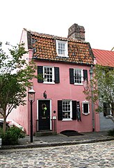
English: The Pink House, built circa 1712, in Charleston, South Carolina, USA. The house is listed on the National Register of Historic Places as a contributing building in the French Quarter District. As was by then typical of the Architecture of Bermuda, the house was built of limestone from Bermuda (Charleston had been settled from Bermuda under William Sayle in the 1670s, and Bermudians retained close links with the city up to American independence). |
| Dagur | |
| Kelda | Egið verk |
| Høvundur | Brian Stansberry |
| Camera location | | View this and other nearby images on: OpenStreetMap |
|---|
| Object location | | View this and other nearby images on: OpenStreetMap |
|---|
Lisensur
I, the copyright holder of this work, hereby publish it under the following license:
This file is licensed under the Creative Commons Attribution 3.0 Unported license.
- Tú ert vælkomin til:
- at deila – at avrita, breiða út og senda verkið
- at remiksa – at tillaga ella broyta verkið
- Undir hesum treytum:
- ognan – Tú mást ognarskrivað verkið á ein slíkan hátt sum er útgreinaður av høvundanum ella lisenseigaranum (men ikki á nakran hátt ið kundi bent á at hesin hevur góðkent teg ella tína nýtslu av verkinum).
Søgan hjá fíluni
Trýst á dato/tíð fyri at síggja fíluna, sum hon sá út tá.
| Dagur/Tíð | Lítil mynd | Dimensjónir | Brúkari | Viðmerking | |
|---|---|---|---|---|---|
| streymur | 22. aug 2017 kl. 18:01 | | 2.095 × 3.064 (1,68 MB) | Migebert | Cropped < 1 % horizontally using CropTool with precise mode. Rotation 90°. |
| 21. aug 2017 kl. 22:00 |  | 2.096 × 3.064 (1,72 MB) | SteinsplitterBot | Bot: Image rotated by 90° (EXIF-Orientation set from 8 to 1, rotated 0°) | |
| 21. aug 2017 kl. 19:22 |  | 3.064 × 2.096 (1,72 MB) | BrineStans | WTF?? | |
| 21. aug 2017 kl. 19:05 |  | 2.048 × 2.560 (1,48 MB) | Cmglee | Crop to subject in question, and try to fix thumbnail. | |
| 13. des 2011 kl. 10:31 |  | 2.096 × 3.064 (1,72 MB) | Rotatebot | Bot: Image rotated by 90° (EXIF-Orientation set from 8 to 1, rotated 0°) | |
| 23. mai 2010 kl. 20:46 |  | 3.064 × 2.096 (1,72 MB) | BrineStans | {{Information |Description={{en|1=The Pink House, built circa 1712, in Charleston, South Carolina, USA. The house is listed on the National Register of Historic Places as a contributing building in the French Quarter District.}} |Source={{own}} |Author=[ |
Myndarslóðir
Hesar síður slóða til hesa mynd:
Alheims fílunýtsla
Aðrar wkiir brúka hesa fílu:
- Nýtsla á de.wikipedia.org
- Nýtsla á en.wikipedia.org
- Charleston, South Carolina
- French Quarter (Charleston, South Carolina)
- List of the oldest buildings in the United States
- National Register of Historic Places listings in Charleston, South Carolina
- List of the oldest buildings in South Carolina
- Pink House (Charleston, South Carolina)
- Draft:Buildings in the Charleston Historic District
- Nýtsla á en.wikivoyage.org
- Nýtsla á fa.wikipedia.org
- Nýtsla á fr.wikipedia.org
- Nýtsla á fy.wikipedia.org
- Nýtsla á it.wikivoyage.org
- Nýtsla á lb.wikipedia.org
- Nýtsla á ru.wikivoyage.org
- Nýtsla á tr.wikipedia.org
- Nýtsla á www.wikidata.org