
Mynd:Mercator projection SW.jpg

Stødd av hesi forskoðan: 707 × 600 pixels. Aðrar upploysnir: 283 × 240 pixels | 566 × 480 pixels | 905 × 768 pixels | 1.207 × 1.024 pixels | 2.058 × 1.746 pixels.
Upprunafíla (2.058 × 1.746 pixel, stødd fílu: 1,01 MB, MIME-slag: image/jpeg)
|
Samandráttur
| Frágreiðing |
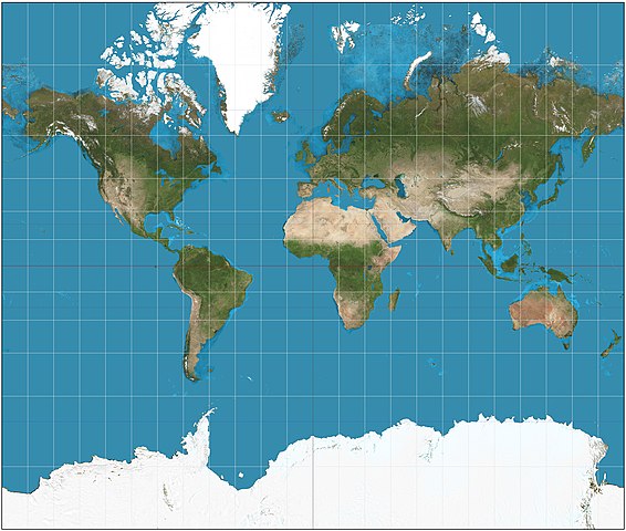
English: The world on Mercator projection between 82°S and 82°N. 15° graticule. Imagery is a derivative of NASA’s Blue Marble summer month composite with oceans lightened to enhance legibility and contrast. Image created with the Geocart map projection software. |
| Dagur | |
| Kelda | Egið verk |
| Høvundur | Strebe |
Lisensur
I, the copyright holder of this work, hereby publish it under the following license:
Henda fíla er gjørd atkomulig undir Creative Commons Navngev-Deil á sama hátt 3.0 Unported loyvinum.
- Tú ert vælkomin til:
- at deila – at avrita, breiða út og senda verkið
- at remiksa – at tillaga ella broyta verkið
- Undir hesum treytum:
- ognan – Tú mást ognarskrivað verkið á ein slíkan hátt sum er útgreinaður av høvundanum ella lisenseigaranum (men ikki á nakran hátt ið kundi bent á at hesin hevur góðkent teg ella tína nýtslu av verkinum).
- deil undir somu treytum – Um tú broytir, evnar til ella byggir víðari á hetta verk, so kanst tú bert útgeva verkið undir somu ella líkandi lisensi sum hesin.
Søgan hjá fíluni
Trýst á dato/tíð fyri at síggja fíluna, sum hon sá út tá.
| Dagur/Tíð | Lítil mynd | Dimensjónir | Brúkari | Viðmerking | |
|---|---|---|---|---|---|
| streymur | 15. aug 2011 kl. 22:35 | | 2.058 × 1.746 (1,01 MB) | Strebe |
Myndarslóðir
Hesar síður slóða til hesa mynd:
Alheims fílunýtsla
Aðrar wkiir brúka hesa fílu:
- Nýtsla á ar.wikipedia.org
- Nýtsla á bg.wikipedia.org
- Nýtsla á bjn.wikipedia.org
- Nýtsla á bn.wikipedia.org
- Nýtsla á cs.wikipedia.org
- Nýtsla á de.wikipedia.org
- Nýtsla á el.wikipedia.org
- Nýtsla á en.wikipedia.org
- User talk:Strebe
- World map
- Wikipedia:Featured pictures/Diagrams, drawings, and maps/Maps
- Talk:Aitoff projection
- Wikipedia:Featured pictures thumbs/35
- Wikipedia:Featured picture candidates/June-2013
- Wikipedia:Featured picture candidates/Map Projections Set
- Wikipedia:Picture of the day/October 2016
- Template:POTD/2016-10-06
- Wikipedia:Main Page history/2016 October 6
- Portal:Geography/Selected picture
- User:LubnaAl/sandbox
- Talk:Mercator projection/Archive 1
- User:ShrillCrayon
- Nýtsla á en.wikibooks.org
- Nýtsla á en.wiktionary.org
- Nýtsla á es.wikipedia.org
- Nýtsla á eu.wikipedia.org
- Nýtsla á fa.wikipedia.org
- Nýtsla á fi.wikipedia.org
- Nýtsla á fi.wiktionary.org
- Nýtsla á fr.wikipedia.org
- Nýtsla á fr.wikiversity.org
- Nýtsla á ha.wikipedia.org
- Nýtsla á he.wikipedia.org
- Nýtsla á hu.wikipedia.org
- Nýtsla á hy.wikipedia.org
- Nýtsla á id.wikipedia.org
- Nýtsla á is.wikipedia.org
- Nýtsla á it.wikipedia.org
- Nýtsla á it.wikibooks.org
- Nýtsla á it.wikiquote.org
Vís meiri globala nýtslu av hesi fílu.