
Mynd:Mediterranean Relief.jpg
Stødd av hesi forskoðan: 800 × 448 pixels. Aðrar upploysnir: 320 × 179 pixels | 640 × 359 pixels | 1.308 × 733 pixels.
Upprunafíla (1.308 × 733 pixel, stødd fílu: 635 KB, MIME-slag: image/jpeg)

|
This map image could be re-created using vector graphics as an SVG file. This has several advantages; see Commons:Media for cleanup for more information. If an SVG form of this image is available, please upload it and afterwards replace this template with
{{vector version available|new image name}}.
It is recommended to name the SVG file “Mediterranean Relief.svg”—then the template Vector version available (or Vva) does not need the new image name parameter. |


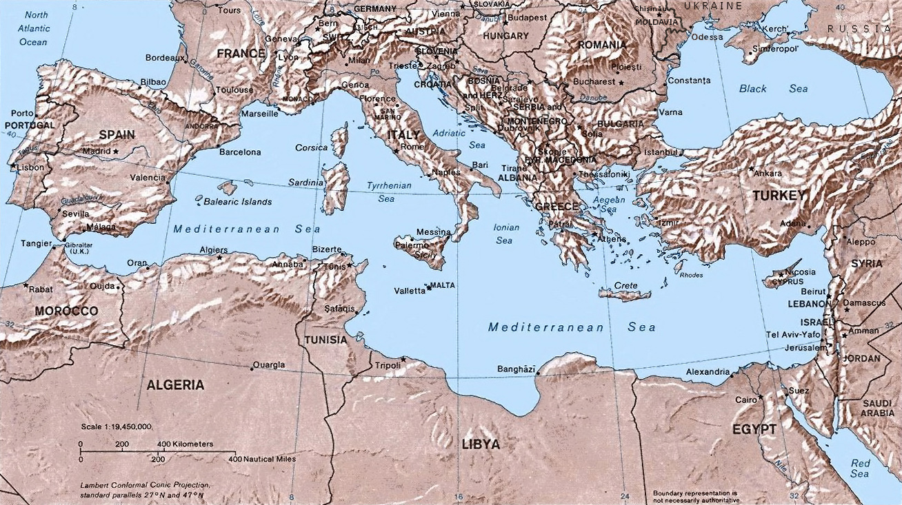
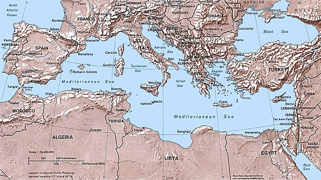
- Shaded relief Map of the Mediterranean Sea - and its Basin and Landforms.
- The original map was created in 1982 by the Central Intelligence Agency ([1], specifically [2]).
- This version was produced by w:User:Joy, who originally uploaded it to the English Wikipedia:
- 23:46, 28 Sep 2004 . . Joy (343433 bytes) (an update after 22 years :) added borders and names for the ex-yu republics (si,hr,ba,cs,mk); corrected names for de,sk; dropped su name but didn't bother drawing the md/uk/ru borders or names because they're not near the topic at hand, and it's tiresome)
![[2]](http://www.lib.utexas.edu/maps/europe/mediterranean_rel82.jpg)
This work is in the public domain in the United States because it is a work prepared by an officer or employee of the United States Government as part of that person’s official duties under the terms of Title 17, Chapter 1, Section 105 of the US Code.
Note: This only applies to original works of the Federal Government and not to the work of any individual U.S. state, territory, commonwealth, county, municipality, or any other subdivision. This template also does not apply to postage stamp designs published by the United States Postal Service since 1978. (See § 313.6(C)(1) of Compendium of U.S. Copyright Office Practices). It also does not apply to certain US coins; see The US Mint Terms of Use.
|
 | |
| This file has been identified as being free of known restrictions under copyright law, including all related and neighboring rights. | ||
Søgan hjá fíluni
Trýst á dato/tíð fyri at síggja fíluna, sum hon sá út tá.
| Dagur/Tíð | Lítil mynd | Dimensjónir | Brúkari | Viðmerking | |
|---|---|---|---|---|---|
| streymur | 6. mai 2016 kl. 14:32 | | 1.308 × 733 (635 KB) | Julieta39 | Actualised the borders |
| 30. mai 2015 kl. 21:38 |  | 1.308 × 733 (614 KB) | Subtropical-man | Reverted to version as of 18:25, 29 August 2011 | |
| 1. sep 2011 kl. 00:59 |  | 1.428 × 800 (400 KB) | Gwillhickers | Larger image, better sharpness | |
| 1. sep 2011 kl. 00:58 |  | 1.428 × 800 (400 KB) | Gwillhickers | Larger ima | |
| 29. aug 2011 kl. 18:25 |  | 1.308 × 733 (614 KB) | Subtropical-man | ||
| 24. aug 2011 kl. 22:21 |  | 1.428 × 800 (400 KB) | Gwillhickers | better sharpness, color tone | |
| 27. jun 2010 kl. 01:01 |  | 1.308 × 733 (614 KB) | Ras67 | rotated and cropped | |
| 4. jun 2010 kl. 20:22 |  | 1.325 × 739 (288 KB) | Cropbot | upload cropped version, operated by User:diaa_abdelmoneim. Summary: cropped | |
| 21. des 2005 kl. 19:22 |  | 1.332 × 792 (274 KB) | Lhgodoy~commonswiki | Noise removal in original image | |
| 4. des 2004 kl. 20:59 |  | 1.332 × 792 (335 KB) | Alfio | Map of the Mediterranean Sea |
Myndarslóðir
Hesar síður slóða til hesa mynd:
Alheims fílunýtsla
Aðrar wkiir brúka hesa fílu:
- Nýtsla á af.wikipedia.org
- Nýtsla á am.wikipedia.org
- Nýtsla á arc.wikipedia.org
- Nýtsla á ar.wikipedia.org
- Nýtsla á arz.wikipedia.org
- Nýtsla á ast.wikipedia.org
- Nýtsla á as.wikipedia.org
- Nýtsla á az.wikipedia.org
- Nýtsla á az.wiktionary.org
- Nýtsla á be.wikipedia.org
- Nýtsla á bo.wikipedia.org
- Nýtsla á bs.wikipedia.org
- Nýtsla á ca.wikipedia.org
- Nýtsla á ceb.wikipedia.org
- Nýtsla á cv.wikipedia.org
- Nýtsla á cy.wikipedia.org
- Nýtsla á da.wikipedia.org
- Nýtsla á de.wikipedia.org
- Nýtsla á dsb.wikipedia.org
- Nýtsla á dty.wikipedia.org
- Nýtsla á el.wikipedia.org
- Nýtsla á en.wikipedia.org
- Nýtsla á en.wiktionary.org
- Nýtsla á eo.wikipedia.org
- Nýtsla á es.wikipedia.org
Vís meiri globala nýtslu av hesi fílu.