
Mynd:Map Dutch World scris.png
Stødd av hesi forskoðan: 800 × 351 pixels. Aðrar upploysnir: 320 × 140 pixels | 640 × 281 pixels | 1.425 × 625 pixels.
Upprunafíla (1.425 × 625 pixel, stødd fílu: 61 KB, MIME-slag: image/png)
Samandráttur
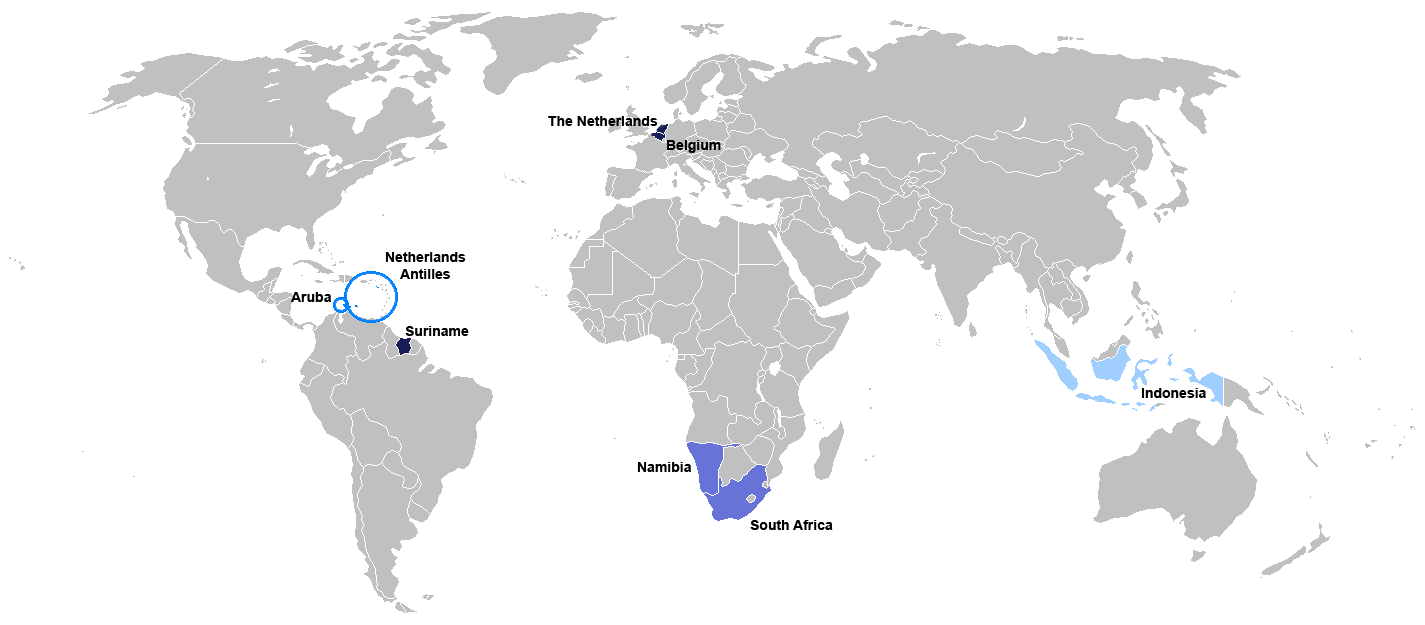
New map for Dutch-speaking world with country names. Modified version of Image:Map Dutch World nou.png
Deutsch: Legende:
- Dunkelblau: Mutter- und Mehrheitssprache
- Blau: Afrikaans (Tochtersprache)
- Hellblau: Zweit- oder nicht offizielle Sprache bzw. weiterhin vorhandene Kenntnis
English: English: Legend:
- Dark blue: native and majority language
- Blue: Afrikaans (daughter language)
- Light blue: secondary (non-official language), where some knowledge persists
Français : Français : Légende:
- Bleu foncé : langue maternelle et majoritaire
- Bleu : Afrikaans («langue fille»)
- Bleu clair : langue secondaire ou non officielle
Italiano: Italiano: Legenda:
- Blu scuro: lingua madre e maggioritaria
- Blu: Afrikaans (lingua affiliata)
- Blu chiaro: seconda lingua e/o non ufficiale, dove la sua conoscenza persiste sino ad oggi
Nederlands: Nederlands: Legenda:
- Donkerblauw: Moedertaal en belangrijkste taal
- Blauw: Afrikaans (dochtertaal)
- Lichtblauw: secundaire taal (niet-officiële taal), waar enkele kennis bestaat
Português: Português: Legenda:
- Azul escuro: língua mãe e majoritária
- Azul: Africâner (língua descendente)
- Azul claro: língua secundária (não oficial), onde ainda persiste algum conhecimento
Română: Română: Legendă:
- Albastru închis: limbă naţională
- Albastru: Afrikaans
- Albastru deschis: limbă secundară, neoficială
Español: Español : Leyenda:
- Azul obscuro : lengua materna y mayoritaria
- Azul : Afrikaans (lengua «hija»)
- Azul claro : lengua secundaria (no oficial), donde aún persiste conocimiento de ella.

|
This file has been superseded by Map of the Dutch World.svg. It is recommended to use the other file. Please note that deleting superseded images requires consent.
|

|
File:Map of the Dutch World.svg is a vector version of this file. It should be used in place of this PNG file.
File:Map Dutch World scris.png → File:Map of the Dutch World.svg
For more information, see Help:SVG. |
 |
Lisensur
I, the copyright holder of this work, hereby publish it under the following license:

|
Loyvi verður givi at avrita, bera út og/ella broyta hetta skjal undir treytunum hjá GNU Free Documentation License, versión 1.2 ella einhvør seinni versjón ið er útgivin av Free Software Foundation; uttan nakað óbroytiligt brot, uttan forsíðutekst og uttan baksíðutekst. Eitt avrit av loyvinum er tikið við í brotinum ið nevnist GNU Free Documentation License. |
| Henda fíla er gjørd atkomulig undir Creative Commons Navngev-Deil á sama hátt 3.0 Unported loyvinum. | ||
| ||
| This licensing tag was added to this file as part of the GFDL licensing update. |
Søgan hjá fíluni
Trýst á dato/tíð fyri at síggja fíluna, sum hon sá út tá.
| Dagur/Tíð | Lítil mynd | Dimensjónir | Brúkari | Viðmerking | |
|---|---|---|---|---|---|
| streymur | 7. jul 2010 kl. 19:06 | | 1.425 × 625 (61 KB) | Hooiwind | deeper colours so it is easier to see the countries on a smaller scale + removal of "minority dots", geographically confusing and pretty arbitrary. |
| 16. feb 2007 kl. 17:46 |  | 1.425 × 625 (34 KB) | Danutz | New map for Dutch-speaking world with country names. Modified version of Image:Map Dutch World nou.png English: Legend: *Dark blue: native language *Blue: administrative language *Light blue: secondary, non-official language *Green square: minori |
Myndarslóðir
Ongar síður slóða til hesa myndina.
Alheims fílunýtsla
Aðrar wkiir brúka hesa fílu:
- Nýtsla á jv.wikipedia.org
- Nýtsla á nl.wikibooks.org
- Nýtsla á sat.wikipedia.org