
Mynd:Landlocked countries.png
Stødd av hesi forskoðan: 800 × 351 pixels. Aðrar upploysnir: 320 × 140 pixels | 640 × 281 pixels | 1.425 × 625 pixels.
Upprunafíla (1.425 × 625 pixel, stødd fílu: 54 KB, MIME-slag: image/png)

|
File:Landlocked countries.svg is a vector version of this file. It should be used in place of this PNG file when not inferior.
File:Landlocked countries.png → File:Landlocked countries.svg
For more information, see Help:SVG. |
 |
Samandráttur
| Frágreiðing | |
| Dagur | |
| Kelda | Egið verk |
| Høvundur | Ævar Arnfjörð Bjarmason |
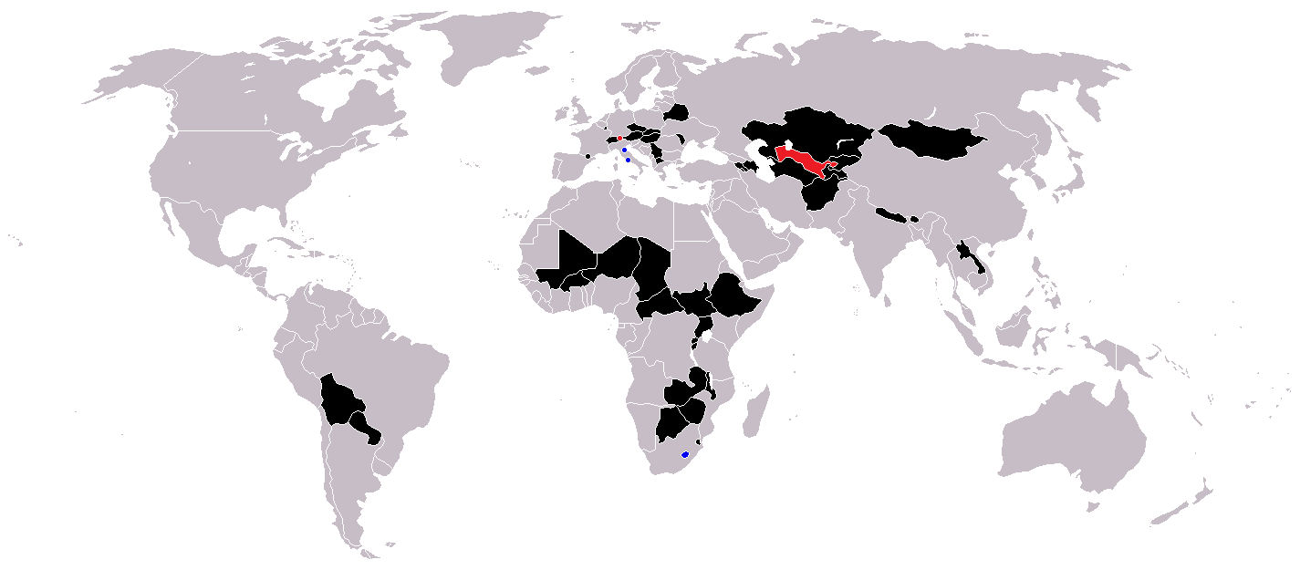
Countries coloured black on the map
Countries coloured red on the map (double landlocked)
Countries coloured blue on the map (landlocked by a single country)
Lisensur
| I, the copyright holder of this work, release this work into the public domain. This applies worldwide. In some countries this may not be legally possible; if so: I grant anyone the right to use this work for any purpose, without any conditions, unless such conditions are required by law. |
Søgan hjá fíluni
Trýst á dato/tíð fyri at síggja fíluna, sum hon sá út tá.
| Dagur/Tíð | Lítil mynd | Dimensjónir | Brúkari | Viðmerking | |
|---|---|---|---|---|---|
| streymur | 1. jun 2018 kl. 12:36 | | 1.425 × 625 (54 KB) | LamBoet | Reverted to version as of 16:39, 15 July 2011 (UTC) - Restore blue color for countries that are landlocked by a single country |
| 2. apr 2018 kl. 21:34 |  | 1.425 × 625 (37 KB) | Maphobbyist | Check | |
| 2. apr 2018 kl. 21:03 |  | 1.425 × 625 (37 KB) | Maphobbyist | Black coloring for San Marino, Vatican and Lesotho. | |
| 15. jul 2011 kl. 16:39 |  | 1.425 × 625 (54 KB) | Hoshie | added South Sudan and added circles foe European microsates | |
| 27. sep 2010 kl. 13:47 |  | 1.425 × 625 (48 KB) | (지금은) 소년시대 | + Landlocked by a single country | |
| 23. okt 2008 kl. 05:33 |  | 1.425 × 625 (48 KB) | IngSoc BigBrother | ||
| 25. feb 2007 kl. 16:14 |  | 1.425 × 625 (30 KB) | Aivazovsky~commonswiki | ||
| 23. mai 2006 kl. 09:29 |  | 1.357 × 628 (46 KB) | Stefan040780 | source: same as old map, updated on 23.5.06 by stefan040780 | |
| 21. jun 2005 kl. 03:08 |  | 1.357 × 628 (25 KB) | Ævar Arnfjörð Bjarmason | Landlocked countries, based on Image:BlankMap-World.png. Category:World maps |
Myndarslóðir
Hesar síður slóða til hesa mynd:
Alheims fílunýtsla
Aðrar wkiir brúka hesa fílu:
- Nýtsla á ckb.wikipedia.org
- Nýtsla á da.wikipedia.org
- Nýtsla á eu.wikipedia.org
- Nýtsla á fa.wikipedia.org
- Nýtsla á fr.wikipedia.org
- Nýtsla á hr.wikipedia.org
- Nýtsla á hu.wikipedia.org
- Nýtsla á is.wiktionary.org
- Nýtsla á ja.wikipedia.org
- Nýtsla á ja.wiktionary.org
- Nýtsla á kk.wikipedia.org
- Nýtsla á ko.wikipedia.org
- Nýtsla á mk.wikipedia.org
- Nýtsla á ms.wikipedia.org
- Nýtsla á nso.wikipedia.org
- Nýtsla á te.wikipedia.org
- Nýtsla á uk.wikipedia.org
- Nýtsla á vi.wikipedia.org
- Nýtsla á zh-yue.wikipedia.org