
Mynd:Japanese Empire - 1942.svg

Size of this PNG preview of this SVG file: 788 × 600 pixels. Aðrar upploysnir: 316 × 240 pixels | 631 × 480 pixels | 1.009 × 768 pixels | 1.280 × 974 pixels | 2.560 × 1.948 pixels | 1.100 × 837 pixels.
Upprunafíla (SVG fíle, nominelt 1.100 × 837 pixel, fíle stødd: 875 KB)
Samandráttur
| Frágreiðing |
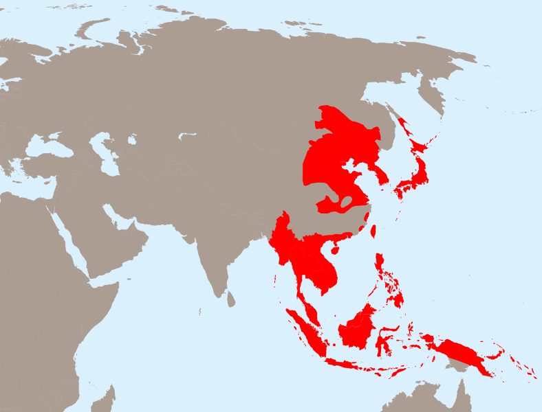
English: The Empire of Japan at its height in 1942.
Français : Japon 1942
Deutsch: Japanisches Reich 1942 |
| Dagur | |
| Kelda | Own work based on: Empire of Japan (1868-1945).png by Mackay 86, Asie.svg by historicair and Japanese Empire2.png by Mackay 86 |
| Høvundur |
Vector: |
| SVG genesis |
.png)
Lisensur
Henda fíla er gjørd atkomulig undir Creative Commons Navngev-Deil á sama hátt 3.0 Unported loyvinum.
- Tú ert vælkomin til:
- at deila – at avrita, breiða út og senda verkið
- at remiksa – at tillaga ella broyta verkið
- Undir hesum treytum:
- ognan – Tú mást ognarskrivað verkið á ein slíkan hátt sum er útgreinaður av høvundanum ella lisenseigaranum (men ikki á nakran hátt ið kundi bent á at hesin hevur góðkent teg ella tína nýtslu av verkinum).
- deil undir somu treytum – Um tú broytir, evnar til ella byggir víðari á hetta verk, so kanst tú bert útgeva verkið undir somu ella líkandi lisensi sum hesin.
Original upload log
This image is a derivative work of the following images:
- Empire of Japan (1868-1945).png licensed with PD-user-w
- 2010-04-13T05:49:21Z File Upload Bot (Magnus Manske) 1000x600 (183888 Bytes) {{BotMoveToCommons|en.wikipedia|year={{subst:CURRENTYEAR}}|month={{subst:CURRENTMONTHNAME}}|day={{subst:CURRENTDAY}}}} {{Information |Description={{en|The Empire of Japan at its height in 1942.}} |Source=Transferred from [ht
- Asie.svg licensed with PD-self
- 2006-11-23T21:09:53Z Historicair 1100x837 (902355 Bytes)
- 2006-11-23T20:25:19Z Historicair 1100x837 (902408 Bytes)
- 2006-11-22T22:59:34Z Historicair 1100x837 (898316 Bytes)
- 2006-11-21T18:36:45Z Historicair 1100x837 (897827 Bytes)
- 2006-11-20T20:31:48Z Historicair 1100x837 (816138 Bytes) {{Information |Description={{fr|1=Carte vierge de l'Asie }}{{en|1=Asia Blank map}} |Source=http://en.wikipedia.org/wiki/Image:BlankMap-World5.svg |Date=20/11/2006 |Author=~~~~ |Permission={{PD-self}} |other_versions= }} {{Atelier g
- Japanese Empire2.png licensed with Cc-by-sa-3.0-migrated, GFDL
- 2007-07-05T11:47:48Z Mahahahaneapneap 707x591 (32385 Bytes) pngcrushed
- 2007-05-27T01:31:13Z Gryffindor 707x591 (49084 Bytes) {{svg}} {{GFDL}} Modified version of [[:Image:Japanese_Empire.png]]. Fixed Ryukyu Islands, Sichuan, grammar in table. [[Category:Maps of the history of Japan]] [[Category:Maps of the history of Korea]] [[Category:Maps of th
- 2007-02-27T15:13:21Z Cristan 508x591 (37210 Bytes) Optimized using PNGOUT
- 2005-12-22T11:24:51Z Markalexander100 508x591 (47890 Bytes) {{GFDL}} Modified version of [[:Image:Japanese_Empire.png]]. Fixed Ryukyu Islands, Sichuan, grammar in table.
Uploaded with derivativeFX
Søgan hjá fíluni
Trýst á dato/tíð fyri at síggja fíluna, sum hon sá út tá.
| Dagur/Tíð | Lítil mynd | Dimensjónir | Brúkari | Viðmerking | |
|---|---|---|---|---|---|
| streymur | 31. mar 2020 kl. 20:13 | | 1.100 × 837 (875 KB) | Esmu Igors | Northern part of the Sakhalin island was transferred from Japan to Soviet Russia in 1925, and the borders remained untouched until the end of WWII. Hence this territory should be omitted from the map. |
| 31. mar 2020 kl. 20:13 |  | 1.100 × 837 (904 KB) | Esmu Igors | Reverted to version as of 01:24, 25 April 2010 (UTC) (unsuccessful edit in the Inkscape) | |
| 31. mar 2020 kl. 20:11 |  | 1.100 × 837 (882 KB) | Esmu Igors | Northern part of the Sakhalin island was transferred from Japan to Soviet Russia in 1925, and the borders remained untouched until the end of WWII. Hence this territory should be omitted from the map. | |
| 25. apr 2010 kl. 01:24 |  | 1.100 × 837 (904 KB) | Ras67 | borders removed | |
| 23. apr 2010 kl. 21:44 |  | 1.100 × 837 (911 KB) | TastyCakes | Tweaked some borders and coloured some islands that I missed | |
| 23. apr 2010 kl. 21:29 |  | 1.100 × 837 (911 KB) | TastyCakes | {{Information |Description={{en|The Empire of Japan at its height in 1942.}} {{fr}}Carte vierge de l'Asie {{en}}Asia Blank map |Source=*File:Empire_of_Japan_(1868-1945).png *File:Asie.svg *File:Japanese_Empire2.png |Date=2010-04-23 21:26 |
.png)
Myndarslóðir
Hesar síður slóða til hesa mynd:
Alheims fílunýtsla
Aðrar wkiir brúka hesa fílu:
- Nýtsla á ar.wikipedia.org
- Nýtsla á bcl.wikipedia.org
- Nýtsla á be.wikipedia.org
- Nýtsla á ca.wikipedia.org
- Nýtsla á cs.wikipedia.org
- Nýtsla á de.wikipedia.org
- Nýtsla á en.wikipedia.org
- Nýtsla á es.wikipedia.org
- Nýtsla á fr.wikipedia.org
- Nýtsla á id.wikipedia.org
- Nýtsla á it.wikipedia.org
- Nýtsla á ja.wikipedia.org
- Nýtsla á km.wikipedia.org
- Nýtsla á ms.wikipedia.org
- Nýtsla á no.wikipedia.org
- Nýtsla á ru.wikipedia.org
- Nýtsla á sv.wikipedia.org
- Nýtsla á th.wikipedia.org
- Nýtsla á tl.wikipedia.org
- Nýtsla á uk.wikipedia.org
- Nýtsla á www.wikidata.org
- Nýtsla á zh-min-nan.wikipedia.org
- Nýtsla á zh-yue.wikipedia.org
- Nýtsla á zh.wikipedia.org
Vís meiri globala nýtslu av hesi fílu.