
Mynd:Hungary map 1941.png

Stødd av hesi forskoðan: 800 × 578 pixels. Aðrar upploysnir: 320 × 231 pixels | 640 × 462 pixels | 1.022 × 738 pixels.
Upprunafíla (1.022 × 738 pixel, stødd fílu: 69 KB, MIME-slag: image/png)
Samandráttur
| Frágreiðing |
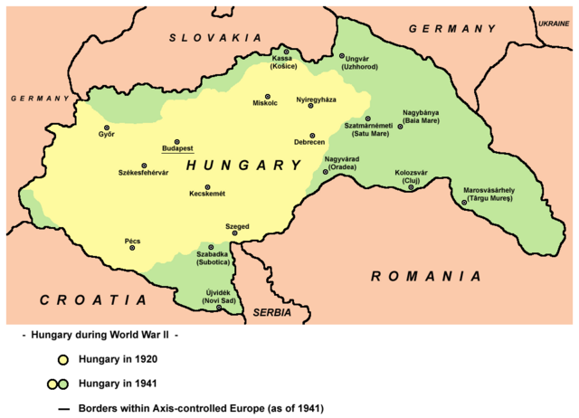
English: Hungary in 1920 and in 1941. |
| Dagur | |
| Kelda | Egið verk |
| Høvundur | User:PANONIAN |
| Other versions |
Derivative works of this file: |
References
- The Times History of Europe, Times Books, London, 2002.
- Richard Overy, The Times History of the 20th Century, Times Books, London, 2004.
- Peter Rokai - Zoltan Đere - Tibor Pal - Aleksandar Kasaš, Istorija Mađara, Beograd, 2002.
- http://terkepek.adatbank.transindex.ro/kepek/netre/224.gif
- http://www.hunmagyar.org/tor/terkep.jpg
- http://www.map.hu/galeria/orig/1426_hu_in_maps_fig_12_states_1648-2009.jpg archive copy at the Wayback Machine
Lisensur
| This work has been released into the public domain by its author, PANONIAN. This applies worldwide. In some countries this may not be legally possible; if so: |

|
This map has been uploaded by Electionworld from en.wikipedia.org to enable the |
Søgan hjá fíluni
Trýst á dato/tíð fyri at síggja fíluna, sum hon sá út tá.
| Dagur/Tíð | Lítil mynd | Dimensjónir | Brúkari | Viðmerking | |
|---|---|---|---|---|---|
| streymur | 11. feb 2014 kl. 19:22 | | 1.022 × 738 (69 KB) | PANONIAN | aesthetics, corrections |
| 11. jul 2010 kl. 10:43 |  | 1.023 × 738 (69 KB) | PANONIAN | Reverted to version as of 19:28, 16 December 2009 - please upload your map as separate file, not over this one | |
| 9. jul 2010 kl. 16:43 |  | 1.023 × 738 (60 KB) | Mix321 | drobne | |
| 16. des 2009 kl. 19:28 |  | 1.023 × 738 (69 KB) | PANONIAN | Reverted to version as of 19:23, 16 December 2009 - fixing thumbnail problem | |
| 16. des 2009 kl. 19:26 |  | 800 × 540 (16 KB) | PANONIAN | Reverted to version as of 23:57, 23 December 2006 - fixing thumbnail problem | |
| 16. des 2009 kl. 19:23 |  | 1.023 × 738 (69 KB) | PANONIAN | improved version | |
| 23. des 2006 kl. 23:57 |  | 800 × 540 (16 KB) | Electionworld | {{ew|en|PANONIAN}} == Licensing == {{PD-user|PANONIAN}} Category:Maps of the history of Hungary Category:Maps of the history of Romania |
Myndarslóðir
Hesar síður slóða til hesa mynd:
Alheims fílunýtsla
Aðrar wkiir brúka hesa fílu:
- Nýtsla á ar.wikipedia.org
- Nýtsla á ast.wikipedia.org
- Nýtsla á ba.wikipedia.org
- Nýtsla á be.wikipedia.org
- Nýtsla á bg.wikipedia.org
- Nýtsla á bs.wikipedia.org
- Nýtsla á ca.wikipedia.org
- Nýtsla á cs.wikipedia.org
- Nýtsla á cv.wikipedia.org
- Nýtsla á en.wikipedia.org
- Nýtsla á eo.wikipedia.org
- Nýtsla á fr.wikipedia.org
- Nýtsla á gl.wikipedia.org
- Nýtsla á he.wikipedia.org
- Nýtsla á hr.wikipedia.org
- Nýtsla á hu.wikipedia.org
- Nýtsla á is.wikipedia.org
- Nýtsla á it.wikipedia.org
- Nýtsla á ja.wikipedia.org
- Nýtsla á jv.wikipedia.org
- Nýtsla á ko.wikipedia.org
- Nýtsla á lt.wikipedia.org
- Nýtsla á nl.wikipedia.org
- Nýtsla á pl.wikipedia.org
- Nýtsla á pt.wikipedia.org
- Nýtsla á ro.wikipedia.org
Vís meiri globala nýtslu av hesi fílu.