
Mynd:Hotel, beach, and shipwreck south of R257 at Bunbeg - geograph.org.uk - 1159653.jpg
Ongin hægri upploysn varð funnin.
Hotel,_beach,_and_shipwreck_south_of_R257_at_Bunbeg_-_geograph.org.uk_-_1159653.jpg (570 × 380 pixel, stødd fílu: 214 KB, MIME-slag: image/jpeg)
Samandráttur
| Frágreiðing |
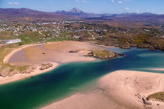
English: Ostan Gweedore Hotel, beach, & shipwreck south of R257 at Gweedore Seen is an inlet to the Atlantic Ocean south of Bunbeg Harbour. This area is east of the Donegal Carrickfin Airport. |
| Dagur | |
| Kelda | From geograph.org.uk |
| Høvundur | Sue Mischyshyn |
| Camera location | | View this and other nearby images on: OpenStreetMap |
|---|
_heading:112.00&language=fo)
| Object location | | View this and other nearby images on: OpenStreetMap |
|---|
_heading:112.00&language=fo)
Lisensur

|
This image was taken from the Geograph project collection. See this photograph's page on the Geograph website for the photographer's contact details. The copyright on this image is owned by Sue Mischyshyn and is licensed for reuse under the Creative Commons Attribution-ShareAlike 2.0 license.
|
This file is licensed under the Creative Commons Attribution-Share Alike 2.0 Generic license.
Ognan: Sue Mischyshyn
- Tú ert vælkomin til:
- at deila – at avrita, breiða út og senda verkið
- at remiksa – at tillaga ella broyta verkið
- Undir hesum treytum:
- ognan – Tú mást ognarskrivað verkið á ein slíkan hátt sum er útgreinaður av høvundanum ella lisenseigaranum (men ikki á nakran hátt ið kundi bent á at hesin hevur góðkent teg ella tína nýtslu av verkinum).
- deil undir somu treytum – Um tú broytir, evnar til ella byggir víðari á hetta verk, so kanst tú bert útgeva verkið undir somu ella líkandi lisensi sum hesin.
Søgan hjá fíluni
Trýst á dato/tíð fyri at síggja fíluna, sum hon sá út tá.
| Dagur/Tíð | Lítil mynd | Dimensjónir | Brúkari | Viðmerking | |
|---|---|---|---|---|---|
| streymur | 25. feb 2011 kl. 10:31 | | 570 × 380 (214 KB) | GeographBot | == {{int:filedesc}} == {{Information |description={{en|1=Hotel, beach, & shipwreck south of R257 at Bunbeg Seen is an inlet to the Atlantic Ocean south of Bunbeg Harbour. This area is east of the Donegal Carrickfin Airport.}} |date=2008-05-04 |source=From |
Myndarslóðir
Hesar síður slóða til hesa mynd:
Alheims fílunýtsla
Aðrar wkiir brúka hesa fílu:
- Nýtsla á bg.wikipedia.org
- Nýtsla á ca.wikipedia.org
- Nýtsla á ceb.wikipedia.org
- Nýtsla á cy.wikipedia.org
- Nýtsla á en.wikipedia.org
- Nýtsla á en.wikivoyage.org
- Nýtsla á eo.wikipedia.org
- Nýtsla á es.wikipedia.org
- Nýtsla á eu.wikipedia.org
- Nýtsla á fa.wikipedia.org
- Nýtsla á fi.wikipedia.org
- Nýtsla á fr.wikivoyage.org
- Nýtsla á ga.wikipedia.org
- Nýtsla á gd.wikipedia.org
- Nýtsla á gl.wikipedia.org
- Nýtsla á gv.wikipedia.org
- Nýtsla á he.wikipedia.org
- Nýtsla á hr.wikipedia.org
- Nýtsla á ig.wikipedia.org
- Nýtsla á it.wikipedia.org
- Nýtsla á ja.wikipedia.org
- Nýtsla á kab.wikipedia.org
- Nýtsla á no.wikipedia.org
- Nýtsla á pt.wikipedia.org
- Nýtsla á ru.wikipedia.org
- Nýtsla á uk.wikipedia.org
- Nýtsla á vls.wikipedia.org
- Nýtsla á www.wikidata.org
- Nýtsla á zh.wikipedia.org