
Mynd:Hallstatt LaTene.png
Ongin hægri upploysn varð funnin.
Hallstatt_LaTene.png (600 × 438 pixel, stødd fílu: 250 KB, MIME-slag: image/png)

|
This historical map image could be re-created using vector graphics as an SVG file. This has several advantages; see Commons:Media for cleanup for more information. If an SVG form of this image is available, please upload it and afterwards replace this template with
{{vector version available|new image name}}.
It is recommended to name the SVG file “Hallstatt LaTene.svg”—then the template Vector version available (or Vva) does not need the new image name parameter. |
| Frágreiðing |
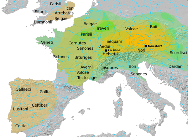
Overview map of the Hallstatt (yellow) and La Tène (green) cultures. After Atlas of the Celtic World, by John Haywood; London Thames & Hudson Ltd., 2001, pp. 30-37. Map update desirable, see here for discussion. |
| Dagur | |
| Kelda | Egið verk |
| Høvundur | Dbachmann |
| Loyvi (Endurnýtsla av hesi fílu) |
GFDL |
Dbachmann, the copyright holder of this work, hereby publishes it under the following license:

|
Loyvi verður givi at avrita, bera út og/ella broyta hetta skjal undir treytunum hjá GNU Free Documentation License, versión 1.2 ella einhvør seinni versjón ið er útgivin av Free Software Foundation; uttan nakað óbroytiligt brot, uttan forsíðutekst og uttan baksíðutekst. Eitt avrit av loyvinum er tikið við í brotinum ið nevnist GNU Free Documentation License. |
| Henda fíla er gjørd atkomulig undir Creative Commons Navngev-Deil á sama hátt 3.0 Unported loyvinum. | ||
| Ognan: Dbachmann | ||
| ||
| This licensing tag was added to this file as part of the GFDL licensing update. |
Søgan hjá fíluni
Trýst á dato/tíð fyri at síggja fíluna, sum hon sá út tá.
| Dagur/Tíð | Lítil mynd | Dimensjónir | Brúkari | Viðmerking | |
|---|---|---|---|---|---|
| streymur | 29. apr 2015 kl. 10:27 | | 600 × 438 (250 KB) | RokerHRO | optopng -o7 -i0 → 11.44% decrease |
| 5. apr 2014 kl. 14:04 |  | 600 × 438 (283 KB) | Zorion | Exit Aquitani. Aquitania has never been celtized. | |
| 6. mai 2008 kl. 16:56 |  | 600 × 438 (312 KB) | Dbachmann | {{Information |Description=Overview map of the Hallstatt (yellow) and La Tène (green) cultures the Hallstatt culture. after [http://faculty.mville.edu/justing/maps.htm#Hallstatt%20Culture%20in%20Central%20Europe Atlas of the Celtic World, by John Haywoo |
Myndarslóðir
Hesar síður slóða til hesa mynd:
Alheims fílunýtsla
Aðrar wkiir brúka hesa fílu:
- Nýtsla á als.wikipedia.org
- Nýtsla á ar.wikipedia.org
- Nýtsla á ast.wikipedia.org
- Nýtsla á bg.wikipedia.org
- Nýtsla á br.wikipedia.org
- Nýtsla á bs.wikipedia.org
- Nýtsla á ca.wikipedia.org
- Nýtsla á cs.wikipedia.org
- Nýtsla á cy.wikipedia.org
- Nýtsla á da.wikipedia.org
- Nýtsla á de.wikipedia.org
- Nýtsla á el.wikipedia.org
- Nýtsla á en.wikipedia.org
Vís meiri globala nýtslu av hesi fílu.