
Mynd:Greatvalley-map.png

Stødd av hesi forskoðan: 587 × 599 pixels. Aðrar upploysnir: 235 × 240 pixels | 624 × 637 pixels.
Upprunafíla (624 × 637 pixel, stødd fílu: 66 KB, MIME-slag: image/png)


|
This map image could be re-created using vector graphics as an SVG file. This has several advantages; see Commons:Media for cleanup for more information. If an SVG form of this image is available, please upload it and afterwards replace this template with
{{vector version available|new image name}}.
It is recommended to name the SVG file “Greatvalley-map.svg”—then the template Vector version available (or Vva) does not need the new image name parameter. |
Samandráttur
| Frágreiðing |
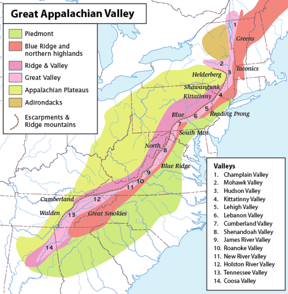
Map of the Appalachian Mountain physiographic regions, highlighting the Great Appalachian Valley, naming the main valleys making it up and the main mountains on either side. Legend:
|
| Dagur | (UTC) |
| Kelda | |
| Høvundur |
|
| This is a retouched picture, which means that it has been digitally altered from its original version. Modifications: converted loselessto PNG. The original can be viewed here: Greatvalley-map.jpg:
|
I, the copyright holder of this work, hereby publish it under the following license:
This file is licensed under the Creative Commons Attribution-Share Alike 2.5 Generic license.
- Tú ert vælkomin til:
- at deila – at avrita, breiða út og senda verkið
- at remiksa – at tillaga ella broyta verkið
- Undir hesum treytum:
- ognan – Tú mást ognarskrivað verkið á ein slíkan hátt sum er útgreinaður av høvundanum ella lisenseigaranum (men ikki á nakran hátt ið kundi bent á at hesin hevur góðkent teg ella tína nýtslu av verkinum).
- deil undir somu treytum – Um tú broytir, evnar til ella byggir víðari á hetta verk, so kanst tú bert útgeva verkið undir somu ella líkandi lisensi sum hesin.
Original upload log
This image is a derivative work of the following images:
- File:Greatvalley-map.jpg licensed with Cc-by-sa-2.5
- 2006-11-14T06:22:37Z Pfly 624x637 (394372 Bytes) {{Information |Description=Map of the Appalachian Mountain physiographic regions, highlighting the Great Appalachian Valley, naming the main valleys making it up and the main mountains on either side. |Source=I made this map
Uploaded with derivativeFX
Søgan hjá fíluni
Trýst á dato/tíð fyri at síggja fíluna, sum hon sá út tá.
| Dagur/Tíð | Lítil mynd | Dimensjónir | Brúkari | Viðmerking | |
|---|---|---|---|---|---|
| streymur | 12. mai 2010 kl. 15:00 | | 624 × 637 (66 KB) | Perhelion | {{Information |Description=Map of the Appalachian Mountain physiographic regions, highlighting the Great Appalachian Valley, naming the main valleys making it up and the main mountains on either side. |Source=*File:Greatvalley-map.jpg |Date=2010-05- |
Myndarslóðir
Hesar síður slóða til hesa mynd:
Alheims fílunýtsla
Aðrar wkiir brúka hesa fílu:
- Nýtsla á bg.wikipedia.org
- Nýtsla á bh.wikipedia.org
- Nýtsla á ca.wikipedia.org
- Nýtsla á cs.wikipedia.org
- Nýtsla á da.wikipedia.org
- Nýtsla á en.wikipedia.org
- Washington County, New York
- Great Appalachian Valley
- Allegheny Front
- Lehigh Valley
- Cumberland Valley
- Talk:Ridge-and-Valley Appalachians
- Lebanon Valley
- Kittatinny Valley
- Gaps of the Allegheny
- Template:User Appalachian diaspora
- User:Hike395/mountain bot diff
- Template:Infobox mountain/test versus status quo ante 3
- Nýtsla á et.wikipedia.org
- Nýtsla á fa.wikipedia.org
- Nýtsla á frr.wikipedia.org
- Nýtsla á fr.wikipedia.org
- Nýtsla á he.wikipedia.org
- Nýtsla á it.wikipedia.org
- Nýtsla á ja.wikipedia.org
- Nýtsla á lt.wikipedia.org
- Nýtsla á ml.wikipedia.org
- Nýtsla á pl.wikipedia.org
- Nýtsla á simple.wikipedia.org
- Nýtsla á uk.wikipedia.org