
Mynd:Faroe islands map with island names.png

Stødd av hesi forskoðan: 450 × 600 pixels. Aðrar upploysnir: 180 × 240 pixels | 600 × 800 pixels.
Upprunafíla (600 × 800 pixel, stødd fílu: 29 KB, MIME-slag: image/png)
Samandráttur
Español: Mapa de las Islas Feroe. Posición del aeropuerto marcado con el avión rojo.
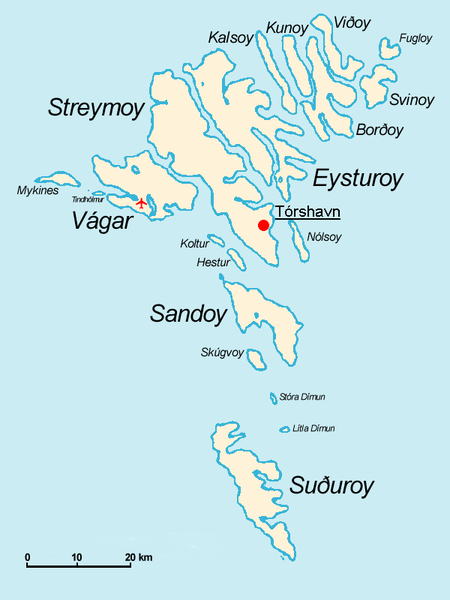
- The Faroe Islands
- Graphics Arne List
- Description: This basic map shows the names of the 18 islands plus the islet Tindhólmur west of Vágar, which is not counted as one of the islands. Furthermore, on this map you see the Airport Vágar and the capital Tórshavn, the two international destinations, if you come via plane or ferry. Last but not least bears the sea no caption, for this map should be translated in different languages by yourself. The sea in the West is the North Atlantic Ocean, and in the East Norwegian Sea (which is a part of the Atlantic).

|
Loyvi verður givi at avrita, bera út og/ella broyta hetta skjal undir treytunum hjá GNU Free Documentation License, versión 1.2 ella einhvør seinni versjón ið er útgivin av Free Software Foundation; uttan nakað óbroytiligt brot, uttan forsíðutekst og uttan baksíðutekst. Eitt avrit av loyvinum er tikið við í brotinum ið nevnist GNU Free Documentation License. |
| Henda fíla er gjørd atkomulig undir Creative Commons Navngev-Deil á sama hátt 3.0 Unported loyvinum. | ||
| ||
| This licensing tag was added to this file as part of the GFDL licensing update. |
derivative works
Derivative works of this file: Faroe islands map with island names-2.JPG
Søgan hjá fíluni
Trýst á dato/tíð fyri at síggja fíluna, sum hon sá út tá.
| Dagur/Tíð | Lítil mynd | Dimensjónir | Brúkari | Viðmerking | |
|---|---|---|---|---|---|
| streymur | 18. nov 2004 kl. 09:32 | | 600 × 800 (29 KB) | Arne List | GFDL |
Myndarslóðir
Hesar síður slóða til hesa mynd:
Alheims fílunýtsla
Aðrar wkiir brúka hesa fílu:
- Nýtsla á azb.wikipedia.org
- Nýtsla á be.wikipedia.org
- Nýtsla á ca.wikipedia.org
- Nýtsla á cs.wikipedia.org
- Nýtsla á da.wikipedia.org
- Nýtsla á de.wikipedia.org
- Nýtsla á ee.wikipedia.org
- Nýtsla á eo.wikipedia.org
- Nýtsla á eu.wikipedia.org
- Nýtsla á ext.wikipedia.org
- Nýtsla á fr.wikipedia.org
- Nýtsla á fr.wiktionary.org
- Nýtsla á ga.wikipedia.org
- Nýtsla á gl.wikipedia.org
- Nýtsla á hu.wikipedia.org
- Nýtsla á id.wikipedia.org
- Nýtsla á is.wikipedia.org
- Nýtsla á mr.wikipedia.org
- Nýtsla á nl.wikipedia.org
- Nýtsla á nn.wikipedia.org
- Nýtsla á no.wikipedia.org
- Nýtsla á os.wikipedia.org
- Nýtsla á pl.wikipedia.org
- Nýtsla á pt.wikipedia.org
- Nýtsla á ru.wikipedia.org
- Nýtsla á sh.wikipedia.org
- Nýtsla á sr.wikipedia.org
- Nýtsla á sv.wikipedia.org
- Nýtsla á vi.wikipedia.org
Vís meiri globala nýtslu av hesi fílu.