
Mynd:Easter Island map-nl.svg

Size of this PNG preview of this SVG file: 800 × 569 pixels. Aðrar upploysnir: 320 × 228 pixels | 640 × 455 pixels | 1.024 × 729 pixels | 1.280 × 911 pixels | 2.560 × 1.821 pixels | 1.750 × 1.245 pixels.
Upprunafíla (SVG fíle, nominelt 1.750 × 1.245 pixel, fíle stødd: 535 KB)
Samandráttur
| Frágreiðing |
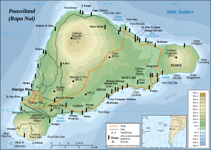
English: Detailed topographic map in Dutch of Easter Island
Français : Carte topographique détaillée en Néerlandais de l'île de Paques
Nederlands: Topografische kaart van Paaseiland
Português: Mapa topográfico detalhado, em Neerlandesa, da Ilha da Páscoa. |
| Dagur | |
| Kelda |
Own work, translation of Image:Easter Island map-fr.svg Background and elevation reference maps : topographic map (IGM map ?) and CIA map Ahu names (ceremonial platforms with moai) : prof. William Mulloy's map (easier to read here) and [1] Locator reference map : National Geographic |
| Høvundur | Eric Gaba (Sting), vertaald door Stuntelaar |
| Loyvi (Endurnýtsla av hesi fílu) |
Creative Commons : share alike - attribution required |
| Other versions |
[]
|


![[1]](http://www.waymarker.co.uk/ml/rapanui/map.jpg)
This W3C-unspecified vector image was created with Inkscape .

|
This SVG file contains embedded text that can be translated into your language, using any capable SVG editor, text editor or the SVG Translate tool. For more information see: About translating SVG files. |
Lisensur
I, the copyright holder of this work, hereby publish it under the following license:
This file is licensed under the Creative Commons Attribution-Share Alike 2.5 Generic license.
- Tú ert vælkomin til:
- at deila – at avrita, breiða út og senda verkið
- at remiksa – at tillaga ella broyta verkið
- Undir hesum treytum:
- ognan – Tú mást ognarskrivað verkið á ein slíkan hátt sum er útgreinaður av høvundanum ella lisenseigaranum (men ikki á nakran hátt ið kundi bent á at hesin hevur góðkent teg ella tína nýtslu av verkinum).
- deil undir somu treytum – Um tú broytir, evnar til ella byggir víðari á hetta verk, so kanst tú bert útgeva verkið undir somu ella líkandi lisensi sum hesin.
Søgan hjá fíluni
Trýst á dato/tíð fyri at síggja fíluna, sum hon sá út tá.
| Dagur/Tíð | Lítil mynd | Dimensjónir | Brúkari | Viðmerking | |
|---|---|---|---|---|---|
| streymur | 22. apr 2008 kl. 19:10 | | 1.750 × 1.245 (535 KB) | Stuntelaar~commonswiki | == Samenvatting == {{Featured picture}} {{Information| |Description={{en|Detailed topographic map in Dutch of Easter Island}} {{fr|Carte topographique détaillée en Néerlandais de l'île de Paques}} {{nl|Topo |
Myndarslóðir
Hesar síður slóða til hesa mynd:
Alheims fílunýtsla
Aðrar wkiir brúka hesa fílu:
- Nýtsla á af.wikipedia.org
- Nýtsla á fy.wikipedia.org
- Nýtsla á nl.wikipedia.org
- Nýtsla á nl.wikivoyage.org