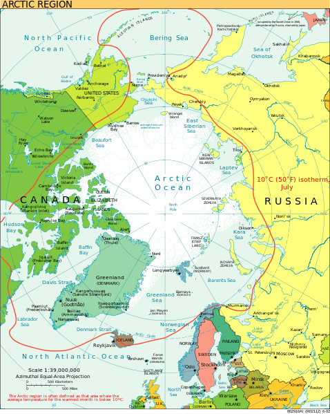
Mynd:Arctic.svg

Size of this PNG preview of this SVG file: 478 × 599 pixels. Aðrar upploysnir: 191 × 240 pixels | 383 × 480 pixels | 613 × 768 pixels | 817 × 1.024 pixels | 1.634 × 2.048 pixels | 505 × 633 pixels.
Upprunafíla (SVG fíle, nominelt 505 × 633 pixel, fíle stødd: 1,5 MB)
Søgan hjá fíluni
Trýst á dato/tíð fyri at síggja fíluna, sum hon sá út tá.
| Dagur/Tíð | Lítil mynd | Dimensjónir | Brúkari | Viðmerking | |
|---|---|---|---|---|---|
| streymur | 11. aug 2023 kl. 21:00 |  | 505 × 633 (1,5 MB) | Mahagaja | correct spelling of Kangiqliniq |
| 9. aug 2009 kl. 18:29 |  | 505 × 633 (1,5 MB) | Ysangkok | compact code, no visible changes afaik | |
| 19. aug 2007 kl. 23:34 |  | 505 × 633 (1,63 MB) | StephenHudson | Reverted to earlier revision | |
| 19. aug 2007 kl. 22:18 |  | 1.010 × 1.267 (1,4 MB) | StephenHudson | Increased base pixel size to make text readable. | |
| 24. jan 2006 kl. 17:17 |  | 505 × 633 (1,63 MB) | Moyogo | stripped useless stuff | |
| 23. jan 2006 kl. 20:32 |  | 505 × 633 (1,95 MB) | Sanao | Arctic<br /> Origin : CIA World Factbook Category:SVG maps Category:Arctic |
Myndarslóðir
Hesar síður slóða til hesa mynd:
Alheims fílunýtsla
Aðrar wkiir brúka hesa fílu:
- Nýtsla á ace.wikipedia.org
- Nýtsla á ady.wikipedia.org
- Nýtsla á af.wikipedia.org
- Nýtsla á ar.wikipedia.org
- Nýtsla á arz.wikipedia.org
- Nýtsla á ast.wikipedia.org
- Nýtsla á as.wikipedia.org
- Nýtsla á ba.wikipedia.org
- Nýtsla á bg.wikipedia.org
- Nýtsla á bn.wikipedia.org
- Nýtsla á ca.wikipedia.org
- Nýtsla á cy.wikipedia.org
- Nýtsla á da.wikipedia.org
- Nýtsla á da.wiktionary.org
- Nýtsla á de.wikipedia.org
- Nýtsla á dty.wikipedia.org
- Nýtsla á el.wikipedia.org
- Nýtsla á en.wikipedia.org
- Geography of Denmark
- Jan Mayen
- Svalbard
- Northern Canada
- History of Svalbard
- Contour line
- List of rivers of the Americas by coastline
- Arctic Bridge
- History of the petroleum industry in Canada (frontier exploration and development)
- Portal:Maps/Maps/Nautical
- Portal:Maps/Maps/Nautical/2
- Arctic Ocean
- Wikipedia:Graphics Lab/Map workshop/Archive/Aug 2009
- Sir James Lamont, 1st Baronet
- Arctic exploration
- Portal:Maps
- Portal:Oceans
- Nýtsla á en.wikibooks.org
- Nýtsla á eo.wikipedia.org
Vís meiri globala nýtslu av hesi fílu.


