
Mynd:AMH-6903-KB Map of the voyage to the 'South Land' by Jacob Roggeveen.jpg

Stødd av hesi forskoðan: 800 × 459 pixels. Aðrar upploysnir: 320 × 184 pixels | 640 × 367 pixels | 1.024 × 588 pixels | 1.280 × 734 pixels | 2.400 × 1.377 pixels.
Upprunafíla (2.400 × 1.377 pixel, stødd fílu: 743 KB, MIME-slag: image/jpeg)
Samandráttur
Nederlands: Kaart van de reis naar het Zuidland door Jacob Roggeveen
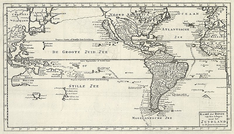
English: Map of the voyage to the 'South Land' by Jacob Roggeveen( |
|||||||||||||||||||||
|---|---|---|---|---|---|---|---|---|---|---|---|---|---|---|---|---|---|---|---|---|---|
| Høvundur |
Creator:Petrus Conradi Creator:Volkert van der Plaats
Nederlands: Petrus Conradi (uitgever), Volkert van der Plaats (uitgever), Dirk de Jong (toegeschreven aan landmeter/kaartenmaker)
English: Petrus Conradi (publisher), Volkert van der Plaats (publisher), Dirk de Jong (assigned to land surveyor / mapmaker) |
||||||||||||||||||||
| Title |
Nederlands: Kaart van de reis naar het Zuidland door Jacob Roggeveen
English: Map of the voyage to the 'South Land' by Jacob Roggeveen |
||||||||||||||||||||
| Frágreiðing |
Nederlands: Kaart van de reis naar het Zuidland door Jacob Roggeveen.
Kaart der Reyze van drie Schepen naar het Zuydland in de Jaren 1721 en 1722. De route van Roggeveen is op de kaart aangegeven, per toeval ontdekte hij Paaseiland.English: Map of the voyage to the 'South Land' by Jacob Roggeveen.
Kaart der Reyze van drie Schepen naar het Zuydland in de Jaren 1721 en 1722. Roggeveen's route is marked on the chart. He discovered Easter Island by accident. |
||||||||||||||||||||
| Dagur | circa 1787 | ||||||||||||||||||||
| Medium |
Nederlands: gravure op papier
English: engraving on paper |
||||||||||||||||||||
| Dimensions | hædd: 36 cm; breidd: 20,5 cm | ||||||||||||||||||||
| Collection |
|
||||||||||||||||||||
| Accession number |
227 K 4 deel XIII, na p. 78 |
||||||||||||||||||||
| Inscriptions |
Kaart der Reyze van drie Schepen naar het Zuydland in de Jaren 1721 en 1722
|
||||||||||||||||||||
| Notes |
English: Subjects: chart / map / plan, banderole / cartouche / ornamentation
Nederlands: Onderwerpen: plattegrond / kaart, banderol / cartouche / versiering
English: Post: this image is related to a VOC trading post called Jakarta |
||||||||||||||||||||
| Source/Photographer |
|
||||||||||||||||||||
| Loyvi (Endurnýtsla av hesi fílu) |
|
||||||||||||||||||||

| Object location | | View this and other nearby images on: OpenStreetMap |
|---|
Søgan hjá fíluni
Trýst á dato/tíð fyri at síggja fíluna, sum hon sá út tá.
| Dagur/Tíð | Lítil mynd | Dimensjónir | Brúkari | Viðmerking | |
|---|---|---|---|---|---|
| streymur | 10. jun 2014 kl. 11:47 | | 2.400 × 1.377 (743 KB) | HuskyBot | == {{int:filedesc}} == {{Artwork |title = {{nl|1=Kaart van de reis naar het Zuidland door Jacob Roggeveen}} {{en|1=Map of the voyage to the 'South Land' by Jacob Roggeveen}} |description = {{nl|1=Kaart van de r... |
Myndarslóðir
Hesar síður slóða til hesa mynd:
Alheims fílunýtsla
Aðrar wkiir brúka hesa fílu:
- Nýtsla á da.wikipedia.org
- Nýtsla á no.wikipedia.org