
Mynd:US insular areas.png

Upprunafíla (1.482 × 624 pixel, stødd fílu: 39 KB, MIME-slag: image/png)

|
File:US insular areas.svg is a vector version of this file. It should be used in place of this PNG file when not inferior.
File:US insular areas.png → File:US insular areas.svg
For more information, see Help:SVG. |
 |
Samandráttur
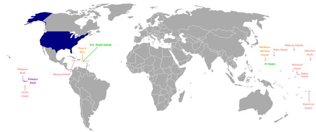
This is a map of the US Insular areas. The first version of this map was based off Image:BlankMap-World-v6.png by User:Astrokey44 with the locations of a few islands added; the source for this are two CIA maps; the maps are a map of the Pacific region and a map of the United States Pacific Island Wildlife Refuges. Hawaii has also been added to the map. Names of the islands are from the CIA Factbook. The second version is based off Image:Dependent_territories_2007.png by User:Sesmith. This map is color-coded according to each island's status:
For an uncolor-coded map, see Image:US_insular_areas-B.png. For a version with the freely associated states, see Image:US_insular_areas FAS.png.
The previous map is under the GFDL; because of this, this map is also.
Lisensur

|
Loyvi verður givi at avrita, bera út og/ella broyta hetta skjal undir treytunum hjá GNU Free Documentation License, versión 1.2 ella einhvør seinni versjón ið er útgivin av Free Software Foundation; uttan nakað óbroytiligt brot, uttan forsíðutekst og uttan baksíðutekst. Eitt avrit av loyvinum er tikið við í brotinum ið nevnist GNU Free Documentation License. |
| Henda fíla er gjørd atkomulig undir Creative Commons Navngev-Deil á sama hátt 3.0 Unported loyvinum. | ||
| ||
| This licensing tag was added to this file as part of the GFDL licensing update. |
Søgan hjá fíluni
Trýst á dato/tíð fyri at síggja fíluna, sum hon sá út tá.
| Dagur/Tíð | Lítil mynd | Dimensjónir | Brúkari | Viðmerking | |
|---|---|---|---|---|---|
| streymur | 2. aug 2014 kl. 06:35 | | 1.482 × 624 (39 KB) | KronosLine | Fix Ukraine, the Caucasus, and added South Sudan. |
| 5. mar 2008 kl. 04:52 |  | 1.482 × 624 (52 KB) | Hoshie | rebuilt using User:Sesmith's maps; more to come. | |
| 17. mar 2007 kl. 10:38 |  | 1.482 × 624 (32 KB) | Hoshie | This is a map of the US Insular areas. The base map is Image:BlankMap-World-v6.png by User:Astrokey44 with the locations of a few islands added; the source for this are two CIA maps; the maps are a [https://www.cia.gov/cia/publications/factbook/ |
Myndarslóðir
Ongar síður slóða til hesa myndina.
Alheims fílunýtsla
Aðrar wkiir brúka hesa fílu:
- Nýtsla á ast.wikipedia.org
- Nýtsla á es.wikipedia.org
- Nýtsla á vi.wikipedia.org
- Nýtsla á www.wikidata.org