
Mynd:Peru Topography.png

Stødd av hesi forskoðan: 442 × 600 pixels. Aðrar upploysnir: 177 × 240 pixels | 354 × 480 pixels | 566 × 768 pixels | 754 × 1.024 pixels | 2.101 × 2.851 pixels.
Upprunafíla (2.101 × 2.851 pixel, stødd fílu: 3,36 MB, MIME-slag: image/png)
Samandráttur
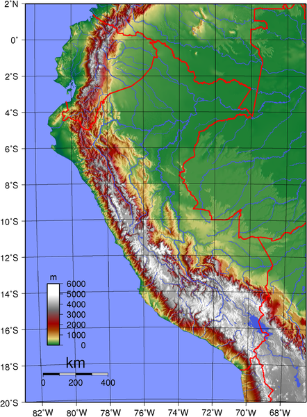
| Frágreiðing | Topographic map of Peru. Created with GMT from GLOBE data. |
| Dagur | |
| Kelda | Egið verk |
| Høvundur | Sadalmelik |
Lisensur
| This work has been released into the public domain by its author, I, Sadalmelik. This applies worldwide. In some countries this may not be legally possible; if so: I, Sadalmelik grants anyone the right to use this work for any purpose, without any conditions, unless such conditions are required by law. |
Søgan hjá fíluni
Trýst á dato/tíð fyri at síggja fíluna, sum hon sá út tá.
| Dagur/Tíð | Lítil mynd | Dimensjónir | Brúkari | Viðmerking | |
|---|---|---|---|---|---|
| streymur | 12. jun 2007 kl. 20:13 | | 2.101 × 2.851 (3,36 MB) | Sadalmelik | {{Information |Description=Topographic map of Peru. Created with GMT from GLOBE data. |Source=self-made |Date=June 12, 2007 |Author= Sadalmelik }} Category:Maps of Peru Category:Topographic maps of the Americas |
Myndarslóðir
Hesar síður slóða til hesa mynd:
Alheims fílunýtsla
Aðrar wkiir brúka hesa fílu:
- Nýtsla á arz.wikipedia.org
- Nýtsla á be.wikipedia.org
- Nýtsla á bg.wikipedia.org
- Nýtsla á ca.wikipedia.org
- Nýtsla á en.wikipedia.org
- Nýtsla á eo.wikipedia.org
- Nýtsla á es.wikipedia.org
- Nýtsla á es.wiktionary.org
- Nýtsla á fi.wikipedia.org
- Nýtsla á frr.wikipedia.org
- Nýtsla á hu.wikipedia.org
- Nýtsla á hy.wikipedia.org
- Nýtsla á id.wikipedia.org
- Nýtsla á io.wikipedia.org
- Nýtsla á ka.wikipedia.org
- Nýtsla á os.wikipedia.org
- Nýtsla á pt.wikipedia.org
- Nýtsla á qu.wikipedia.org
Vís meiri globala nýtslu av hesi fílu.