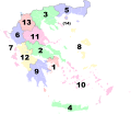
Mynd:Peripheries of Greece numbered.svg

Size of this PNG preview of this SVG file: 693 × 599 pixels. Aðrar upploysnir: 278 × 240 pixels | 555 × 480 pixels | 888 × 768 pixels | 1.184 × 1.024 pixels | 2.369 × 2.048 pixels | 8.460 × 7.315 pixels.
Upprunafíla (SVG fíle, nominelt 8.460 × 7.315 pixel, fíle stødd: 2 MB)
Søgan hjá fíluni
Trýst á dato/tíð fyri at síggja fíluna, sum hon sá út tá.
| Dagur/Tíð | Lítil mynd | Dimensjónir | Brúkari | Viðmerking | |
|---|---|---|---|---|---|
| streymur | 5. mar 2023 kl. 05:22 |  | 8.460 × 7.315 (2 MB) | Aris Odi | Minor fix |
| 17. feb 2023 kl. 02:38 |  | 8.460 × 7.315 (2 MB) | Aris Odi | Made corrections and tidied-up file | |
| 21. jun 2017 kl. 12:43 |  | 8.460 × 7.315 (2 MB) | SilentResident | This time bug has been fixed for real by deleting all Flowed Text boxes manually in the .svg's source code, using a XML editor. | |
| 20. jun 2017 kl. 17:45 |  | 8.460 × 7.315 (2 MB) | SilentResident | Removed the - next to number 7. | |
| 17. jan 2015 kl. 20:29 |  | 8.460 × 7.315 (2 MB) | SilentResident | Added the missing islands of Megisti and Strogyli. | |
| 9. aug 2011 kl. 14:56 |  | 7.304 × 7.315 (1,8 MB) | Sarah fides | {{Information |Description={{en|1=The peripheries of Greece (2011), numbered.}} |Source=*File:Greek_Macedonia_map_with_subdivisions.svg |Date=2011-08-09 14:54 (UTC) |Author=*File:Greek_Macedonia_map_with_subdivisions.svg: *[[:File:Greece_2011_ |
Myndarslóðir
Hesar síður slóða til hesa mynd:
Alheims fílunýtsla
Aðrar wkiir brúka hesa fílu:
- Nýtsla á an.wikipedia.org
- Nýtsla á az.wikipedia.org
- Nýtsla á bbc.wikipedia.org
- Nýtsla á bn.wikipedia.org
- Nýtsla á bs.wikipedia.org
- Nýtsla á cs.wikipedia.org
- Nýtsla á da.wikipedia.org
- Nýtsla á el.wikivoyage.org
- Nýtsla á en.wikipedia.org
- Nýtsla á eu.wikipedia.org
- Nýtsla á gl.wikipedia.org
- Nýtsla á ia.wikipedia.org
- Nýtsla á id.wikipedia.org
- Nýtsla á incubator.wikimedia.org
- Nýtsla á is.wikipedia.org
- Nýtsla á it.wikipedia.org
- Nýtsla á ja.wikipedia.org
- Nýtsla á ku.wikipedia.org
- Yewnanistan
- Krît
- Parêzgehên Yewnanistanê
- Atîka (parêzgeh)
- Yewnanistana Navîn (parêzgeh)
- Makedonyaya Navîn (parêzgeh)
- Makedonyaya Rojhilat û Trakya (parêzgeh)
- Êpîros (parêzgeh)
- Şablon:Parêzgehên Yewnanistanê
- Giravên Yonî (parêzgeh)
- Egeya Bakur (parêzgeh)
- Peloponês (parêzgeh)
- Egeya Başûr (parêzgeh)
- Tesalya (parêzgeh)
- Yewnanistana Rojava (parêzgeh)
- Makedonyaya Rojava (parêzgeh)
- Nýtsla á lfn.wikipedia.org
- Nýtsla á new.wikipedia.org
- Nýtsla á pt.wikipedia.org
- Nýtsla á ro.wikipedia.org
- Nýtsla á ru.wikipedia.org
- Nýtsla á sh.wikipedia.org
- Nýtsla á sl.wikipedia.org
- Nýtsla á su.wikipedia.org
- Nýtsla á test2.wikipedia.org
- Nýtsla á tr.wikipedia.org
- Nýtsla á vi.wikipedia.org
- Nýtsla á zh.wikipedia.org
