
Mynd:Newfoundland and Labrador-map.png
Ongin hægri upploysn varð funnin.
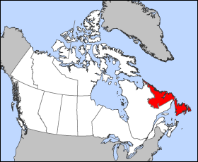
Newfoundland_and_Labrador-map.png (280 × 230 pixel, stødd fílu: 14 KB, MIME-slag: image/png)
Map of Newfoundland and Labrador
Projection: Lambert azimuthal equal-area
Geospatial data from: The Atlas of Canada, The National Atlas of the United States and U.S. Geological Survey
Cartographer: John Fowler
| I, the copyright holder of this work, release this work into the public domain. This applies worldwide. In some countries this may not be legally possible; if so: I grant anyone the right to use this work for any purpose, without any conditions, unless such conditions are required by law. |
Søgan hjá fíluni
Trýst á dato/tíð fyri at síggja fíluna, sum hon sá út tá.
| Dagur/Tíð | Lítil mynd | Dimensjónir | Brúkari | Viðmerking | |
|---|---|---|---|---|---|
| streymur | 24. mar 2005 kl. 12:15 | | 280 × 230 (14 KB) | Voyager | Map of Newfoundland and Labrador Projection: Lambert azimuthal equal-area Geospatial data from: [http://atlas.gc.ca/ The Atlas of Canada], [http://www.nationalatlas.gov/ The National Atlas of the United States] and [http://www.usgs.gov U.S. Geological S |
Myndarslóðir
Hesar síður slóða til hesa mynd:
Alheims fílunýtsla
Aðrar wkiir brúka hesa fílu:
- Nýtsla á bat-smg.wikipedia.org
- Nýtsla á br.wikipedia.org
- Nýtsla á da.wikipedia.org
- Nýtsla á en.wikipedia.org
- Nýtsla á en.wikinews.org
- Nýtsla á en.wiktionary.org
- Nýtsla á eo.wikipedia.org
- Nýtsla á es.wikipedia.org
- Nýtsla á frr.wikipedia.org
- Nýtsla á fr.wikinews.org
- Nýtsla á gd.wikipedia.org
- Nýtsla á hu.wikipedia.org
- Nýtsla á hu.wiktionary.org
- Nýtsla á hy.wikipedia.org
- Nýtsla á incubator.wikimedia.org
- Nýtsla á is.wikipedia.org
- Nýtsla á ja.wikipedia.org
- Nýtsla á kw.wikipedia.org
- Nýtsla á lij.wikipedia.org
- Nýtsla á mk.wikipedia.org
- Nýtsla á ms.wikipedia.org
- Nýtsla á nn.wikipedia.org
- Nýtsla á pam.wikipedia.org
- Nýtsla á pms.wikipedia.org
- Nýtsla á sc.wikipedia.org
- Nýtsla á ta.wikipedia.org
- Nýtsla á uk.wikipedia.org
- Nýtsla á vo.wikipedia.org
- Nýtsla á xmf.wikipedia.org
- Nýtsla á yi.wikipedia.org
- Nýtsla á yo.wikipedia.org
- Nýtsla á zh-min-nan.wikipedia.org