
Mynd:Map-position-vaga-kommuna-2009.png

Stødd av hesi forskoðan: 450 × 600 pixels. Aðrar upploysnir: 180 × 240 pixels | 600 × 800 pixels.
Upprunafíla (600 × 800 pixel, stødd fílu: 32 KB, MIME-slag: image/png)
Samandráttur
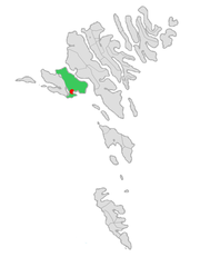
| Frágreiðing | Map of Vaga kommuna in the Faroe Islands. |
| Dagur | |
| Kelda | Own work, based on map by Arne List |
| Høvundur | Erik Fløan |
Lisensur
| I, the copyright holder of this work, release this work into the public domain. This applies worldwide. In some countries this may not be legally possible; if so: I grant anyone the right to use this work for any purpose, without any conditions, unless such conditions are required by law. |
Søgan hjá fíluni
Trýst á dato/tíð fyri at síggja fíluna, sum hon sá út tá.
| Dagur/Tíð | Lítil mynd | Dimensjónir | Brúkari | Viðmerking | |
|---|---|---|---|---|---|
| streymur | 11. jan 2009 kl. 12:51 | | 600 × 800 (32 KB) | Efloean | {{Information |Description=Map of Vaga kommuna in the Faroe Islands. |Source=Own work, based on map by Arne List |Date=January 11, 2009 |Author= Erik Fløan |Permission= |other_versions= }} [[Category:Map of municipali |
Myndarslóðir
Hesar síður slóða til hesa mynd:
Alheims fílunýtsla
Aðrar wkiir brúka hesa fílu:
- Nýtsla á ca.wikipedia.org
- Nýtsla á da.wikipedia.org
- Nýtsla á de.wikipedia.org
- Nýtsla á en.wikipedia.org
- Nýtsla á es.wikipedia.org
- Nýtsla á fi.wikipedia.org
- Nýtsla á fr.wikipedia.org
- Nýtsla á gl.wikipedia.org
- Nýtsla á hu.wikipedia.org
- Nýtsla á it.wikipedia.org
- Nýtsla á lt.wikipedia.org
- Nýtsla á nl.wikipedia.org
- Nýtsla á no.wikipedia.org
- Nýtsla á pl.wikipedia.org
- Nýtsla á ru.wikipedia.org
- Nýtsla á sv.wikipedia.org
- Nýtsla á www.wikidata.org
- Nýtsla á zh.wikipedia.org