
Mynd:ElectoralCollege2012.svg

Size of this PNG preview of this SVG file: 800 × 465 pixels. Aðrar upploysnir: 320 × 186 pixels | 640 × 372 pixels | 1.024 × 595 pixels | 1.280 × 744 pixels | 2.560 × 1.488 pixels | 1.020 × 593 pixels.
Upprunafíla (SVG fíle, nominelt 1.020 × 593 pixel, fíle stødd: 29 KB)
Samandráttur
| U.S. presidential election maps (SVG) |
| See also: National Atlas maps (png) |
|
1789 · 1792 · 1796 · 1800 · 1804 · 1808 · 1812 · 1816 · 1820 · 1824 · 1828 · 1832 · 1836 · 1840 · 1844 · 1848 · 1852 · 1856 · 1860 · 1864 · 1868 · 1872 · 1876 · 1880 · 1884 · 1888 · 1892 · 1896 · 1900 · 1904 · 1908 · 1912 · 1916 · 1920 · 1924 · 1928 · 1932 · 1936 · 1940 · 1944 · 1948 · 1952 · 1956 · 1960 · 1964 · 1968 · 1972 · 1976 · 1980 · 1984 · 1988 · 1992 · 1996 · 2000 · 2004 · 2008 · 2012 · 2016 · 2020 · 2024 |
| Frágreiðing |
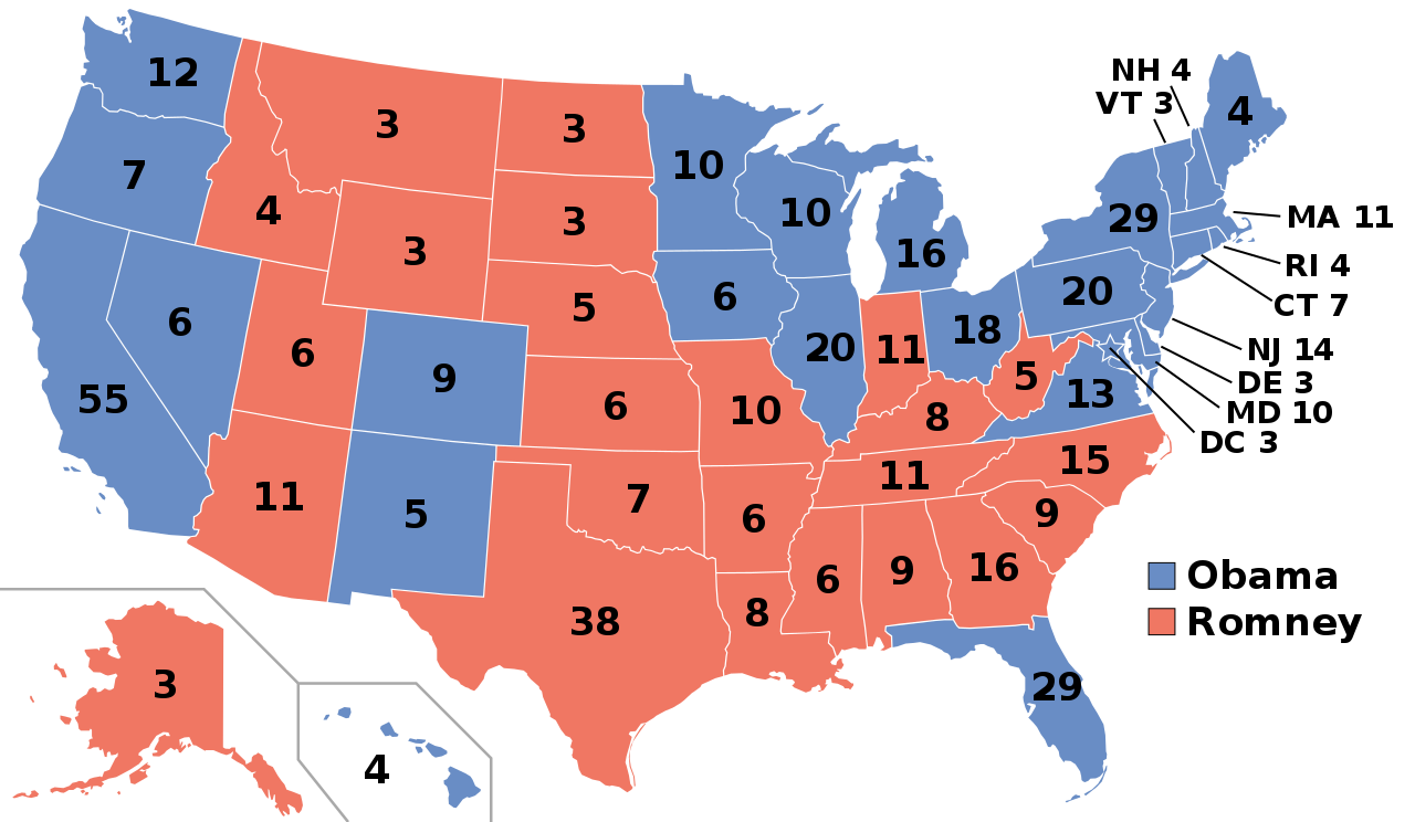
English: Electoral college map for the 2012 United States presidential election (note: Nebraska and Maine split their EVs by congressional district).
Sources used: Pollster.com, CNN.com, MSNBC.com, AP.org, and FOXNews.com |
||
| Dagur | |||
| Kelda | Egið verk | ||
| Høvundur | Gage | ||
| Loyvi (Endurnýtsla av hesi fílu) |
|
||
| Other versions |
Electoral College 2012.svg: |
||
| SVG genesis | This map was created with unknown tool. |
Søgan hjá fíluni
Trýst á dato/tíð fyri at síggja fíluna, sum hon sá út tá.
| Dagur/Tíð | Lítil mynd | Dimensjónir | Brúkari | Viðmerking | |
|---|---|---|---|---|---|
| streymur | 20. nov 2018 kl. 02:55 | | 1.020 × 593 (29 KB) | Newfraferz87 | Simplify further: coordinates & fills, following this |
| 18. jan 2017 kl. 14:48 |  | 1.020 × 593 (35 KB) | Newfraferz87 | Clearer state borders | |
| 22. jul 2016 kl. 13:50 |  | 1.020 × 593 (35 KB) | Newfraferz87 | Group fonts | |
| 12. jul 2016 kl. 07:18 |  | 1.020 × 593 (36 KB) | Newfraferz87 | Adjust frames | |
| 10. jul 2016 kl. 14:12 |  | 1.020 × 593 (36 KB) | Newfraferz87 | Adjust legend | |
| 10. jul 2016 kl. 14:06 |  | 1.020 × 593 (36 KB) | Newfraferz87 | Overhaul, based on blank states map. Adjust there if there are outstanding border/boundary issues. Thanks | |
| 10. nov 2012 kl. 05:52 |  | 1.020 × 593 (112 KB) | Denelson83 | Reverted to version as of 01:10, 9 November 2012: Florida has officially been given to Obama | |
| 9. nov 2012 kl. 11:23 |  | 1.020 × 593 (116 KB) | Words in the Wind | Reverted to version as of 01:29, 9 November 2012 Florida is leaning democratic, yet to be conceded. not republican | |
| 9. nov 2012 kl. 11:12 |  | 1.020 × 593 (116 KB) | M0tty | Update Floride | |
| 9. nov 2012 kl. 01:29 |  | 1.020 × 593 (116 KB) | Gwickwire | Reverted to version as of 00:07, 9 November 2012 doesn't matter, doesn't mean obama has won. just cause romney conceded doesnt mean votes are all counted and obama has more votes. |
.svg)
Myndarslóðir
Hesar síður slóða til hesa mynd:
Alheims fílunýtsla
Aðrar wkiir brúka hesa fílu:
- Nýtsla á af.wikipedia.org
- Nýtsla á ar.wikipedia.org
- Nýtsla á arz.wikipedia.org
- Nýtsla á be.wikipedia.org
- Nýtsla á bg.wikipedia.org
- Nýtsla á bn.wikipedia.org
- Nýtsla á bo.wikipedia.org
- Nýtsla á bs.wikipedia.org
- Nýtsla á ca.wikipedia.org
- Nýtsla á ca.wikinews.org
- Nýtsla á cdo.wikipedia.org
- Nýtsla á cs.wikipedia.org
- Nýtsla á cy.wikipedia.org
- Nýtsla á da.wikipedia.org
- Nýtsla á de.wikipedia.org
- Nýtsla á el.wikipedia.org
- Nýtsla á en.wikipedia.org
- Political colour
- Mitt Romney
- Barack Obama
- Electoral vote changes between United States presidential elections
- List of United States presidential election results by state
- Electoral history of Barack Obama
- Electoral history of Mitt Romney
- Electoral history of Joe Biden
- Presidency of Barack Obama
- 2012 United States presidential election
- United States presidential election
- 2012 United States elections
- 2012 United States presidential election in Iowa
- 2012 United States presidential election in New Hampshire
- 2012 United States presidential election in South Carolina
- 2012 United States presidential election in Nevada
- 2012 in the United States
- 2012 United States presidential election in Maine
- 2012 United States presidential election in Colorado
Vís meiri globala nýtslu av hesi fílu.