
Mynd:Chechnya03.png
Stødd av hesi forskoðan: 524 × 599 pixels. Aðrar upploysnir: 210 × 240 pixels | 420 × 480 pixels | 677 × 774 pixels.
Upprunafíla (677 × 774 pixel, stødd fílu: 38 KB, MIME-slag: image/png)
Samandráttur
| Frágreiðing |
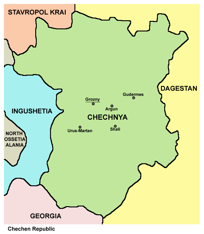
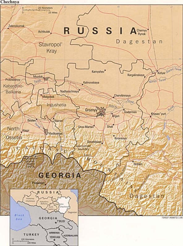
English: map of Chechnya, labelled in English
Esperanto: skema mapo de Ĉeĉenio, priskriboj en la angla |
| Dagur | |
| Kelda | Egið verk |
| Høvundur | PANONIAN |
| Other versions |
Chechnya03 af.png (Afrikaans), Ĉeĉenio.png (Esperanto), Ĉeĉenio sen nomoj.png (blank) Converted to SVG: Ĉeĉenio.svg (Esperanto), Ĉeĉenio DE.svg (German), Ĉeĉenio LT.svg (Lithuanian) |
Lisensur

|
This map has been uploaded by Electionworld from en.wikipedia.org to enable the |
Map made by PANONIAN
| This work has been released into the public domain by its author, PANONIAN. This applies worldwide. In some countries this may not be legally possible; if so: |
References
- http://www.mapzones.com/citymap/russia/chechnya/chechnya.jpg
- http://www.worldatlas.com/webimage/countrys/europe/chechsml.gif
- http://mapas.owje.com/img/Mapa-de-Relieve-Sombreado-de-Chechenia-Rusia-4739.jpg
- http://www.infoplease.com/images/mchechnya.gif
- http://boes.org/child/russia/images/mapchechnya4.jpg
- http://www.robinsonlibrary.com/history/eastern/russia/russia/graphics/chechnya-map.jpg archive copy at the Wayback Machine
- http://www.bestcountryreports.com/media/D_Images/Chechn_Pol.jpg
- http://rdaward.org/map/6p.jpg
- http://galgai.com/misc/ChechenIngushMap.jpg
- http://t1.ftcdn.net/jpg/00/37/98/16/400_F_37981654_ihQ94XNq7FqYvyOyjZtaqTLTQ8SDLr1u.jpg
- http://img.timeinc.net/time/photoessays/grozny/images/map.gif
- http://lh4.ggpht.com/-V5LOo3pqLNc/S8Uwzwc3vqI/AAAAAAAAAWw/v4_PKVb19o4/chechnya4.gif.jpg
Søgan hjá fíluni
Trýst á dato/tíð fyri at síggja fíluna, sum hon sá út tá.
| Dagur/Tíð | Lítil mynd | Dimensjónir | Brúkari | Viðmerking | |
|---|---|---|---|---|---|
| streymur | 1. feb 2020 kl. 15:39 | | 677 × 774 (38 KB) | PANONIAN | Reverted to version as of 16:36, 16 April 2012 (UTC) - please upload your map version under different file name |
| 16. jan 2020 kl. 22:58 |  | 8.770 × 8.963 (1,51 MB) | Takhirgeran Umar | об | |
| 16. jan 2020 kl. 22:49 |  | 8.231 × 8.437 (1,46 MB) | Takhirgeran Umar | Between the republics have established borders. Until 2018, there were no borders. | |
| 16. apr 2012 kl. 16:36 |  | 677 × 774 (38 KB) | PANONIAN | improved version | |
| 29. des 2006 kl. 16:10 |  | 530 × 601 (18 KB) | Electionworld | {{ew|en|PANONIAN}} Map made by PANONIAN {{PD-user|PANONIAN}} Category:Maps of the Russian republics |
Myndarslóðir
Ongar síður slóða til hesa myndina.
Alheims fílunýtsla
Aðrar wkiir brúka hesa fílu:
- Nýtsla á ru.wikinews.org